Cleopatra's Map
Franck Goddio, the underwater archaeologist who has been exploring the murky waters off Alexandria, has made a number of amazing discoveries. Chief of these are the remains of the Pharos, the famous lighthouse that guided shipping into the harbour; he also discovered Cleopatra's palace, long submerged below the sea.
These things, however, are peripheral to his real project, which is nothing less than a map of the whole of Alexandria's ancient harbour. After nearly ten years of work, he unveiled the first complete map of the port to coincide with the opening of the Cleopatra exhibition at the British Musem in 2001.
To be quite honest, the map holds no great surprises. The port of Alexandria was sufficiently famous that it is described, either in detail or in passing, by a number of ancient authors and these descriptions, combined with the modern topography, enabled us to have a pretty good idea of how the harbour was arranged. It is in the detail that Goddio excels.
For example, he has found that there were a number of man-made breakwaters in the area of the Poseidium peninsula and that these were made of a type of mortar that would set underwater. Wooden posts embedded in the morter before it set supported walkways, but the remains of these posts enabled Goddio to date the structure to the Ptolemaic period, about 250 BC. This has forced archaeologists to re-think their understanding of ancient skills, because it was previously thought that such techniques were invented by the Romans and earlier builders had been forced to simply drop stones over the side of a ship or barge until the underwater construction reached the desired height.
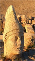
Other discoveries have included a 90 foot long Roman ship, the foundations of a temple of Isis with a statue of the high priest, a colossal head of Caesarion, Cleopatra's son by Julius Caesar, and various architectural fragments.
The work of mapping the harbour and plotting the ancient remains would not have been possible without the modern equipment of Global Positioning. The water in the modern harbour is so polluted that visibility has often been less than two or three feet, making it impossible to map things by eye. Divers have gone to one end of an obelisk, say, and pressed their GPS receiver against it, noted the coordinates and then gone to the other end and done the same thing. Back on the surface they use the coordinates to plot the size and orientation of the obelisk and then go down to measure something else. This has resulted in a map which is accurate down to two inches - probably as good if not better than could be achieved on the surface using normal surveying equipment.
Despite the publication of the map, Goddio cheerfully admits that he and his team have a lot more work to do. It is yet to be seen what lies underneath some of the structures which have been discovered, for so far the work has merely been surveying, not excavating. Although many of the structures date from only a few decades after the founding of the city of Alexandria, it is quite possible that such an excellent natural harbour had been used long before Alexander came that way.
A new video from Digging Up the Past
Filmed in May 2001, discover the fascinating story of battles, court intrigues and royal love affairs in the city known as Byzantium. In Roman times it became "Constantinople", which was corrupted in Ottoman times to "Istanbul". Graphically narrated by Kendall Down, let him be your tour guide through this history-saturated city.
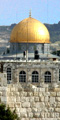
In this video Kendall Down takes you to Haghia Sophia, the Roman hippodrome, the massive city walls, the huge underground cistern and many other places of historical interest in Istanbul.
This is history at its best - and for good measure we have included on the tape a video report of our tour group working on the 2001 dig in Israel where we found and excavated an intact tomb at the ancient site of Mareshah.
A total of 55 minutes of fascinating film. To order, please visit our on-line shop. The video is available in both PAL and NTSC (for north America) formats.