Archaeology and the Bible
Exodus - 2
| Jebel Katerina | 28 32 20.22N 33 58 29.16E | The pointer should be directly above the Greek Orthodox chapel which stands on the summit of Mt Sinai. |
| Jebel Musa | 28 33 23.32N 33 57 44.87E | This is the view of Mt Sinai from the plain to the north of the mountain, and which you see in the banner at the top of the page. Jebel Katerina is not visible from the plain. |
| Jebel Rum | 29 39 51.41N 35 27 43.22E | I believe the pointer is over Jebel Rum, an isolated outcrop of rock which some have identified as Mt Sinai. There are enough beautiful photographs to give you an idea of the place. |
| Jebel al-Lawz | 28 39 12.94N 35 18 15.90E | I believe the pointer is above the peak whose dark rock summit claimed to show the effect of God appearing on it. A suitable flat plain for the Israelite encampment is hard to find. |
| Jebel Ideid | 30 17 37.53N 34 44 01.59E | Known to the Jews as Har Karkom, Jebel Ideid is the only one of the four to have signs of human activity on and around the mountain. Some of the pictures on Google Earth show rock graffiti allegedly linked to Mt Sinai. |
| Jebel al-Madhbah | 30 19 20.40N 35 26 50.41E | This is, perhaps, the unlikeliest of all the sites proposed for Mt Sinai! |
The Exodus Route
Three routes have been proposed for the Exodus - the northern, the central and the southern. We need not waste much time on the northern, which proposes that the Israelites travelled up to the coast, experienced some sort of "parting of the waters" in the shallow sea between Damietta and Port Said, then continued along the coast and entered Palestine near Gaza. This route is explicitly ruled out by the statement in Exodus 13:17 that they did not follow the route through the land of the Philistines.
Both the central and the southern routes envisage a crossing at the other end of the Suez Canal, either through the Bitter Lakes or through the Gulf of Suez, after which the central route goes straight across the heart of the Sinai Peninsula to the Gulf of Aqaba while the southern route turns south towards the traditional Mt Sinai, Jebel Katerina.
There are two reasons why this is the preferred route out of Egypt. The first is that there is a wide wadi, the Wadi Tumilat, leading from Cairo to Suez with blocks of mountainous country to north and south - these can be clearly seen on a map program such as Google Earth. It is inevitable that any large body of people, especially if they were encumbered with flocks and herds, would travel along this flat and level wadi if they were heading towards the Sinai Peninsula.
The second reason is that the Egyptians, faced with the problem of illegal immigration from Palestine into Egypt had adopted the American technique and built a wall all the way from the Mediterranean to the Gulf of Suez. The "Walls of the Ruler" were begun by Amenemhet I and were an elaboration of the earlier "Walls of Sneferu". The wall has not been found - yet - but individual forts have been identified. In addition, pictures from the New Kingdom appear to shows forts surrounded by crocodile-infested ditches and linked by canals that were crossed by bridges.
Although the military forces guarding the wall could have been easily overcome by the million or more Israelites, getting the flocks and herds across the wall or the crocodile-infested ditches was another matter entirely. They would have been forced to use one or more of the gates through the wall or bridges across the ditches and getting that many people and animals through the narrow passageways would have taken considerable time - during which reinforcements would have arrived from other parts of the frontier zone and battle would have been continuous.
In addition excavations have revealed a chain of forts running parallel to the wall and along the Way of Horus, as the road to Palestine was known, so that even when the Israelites had passed the wall they would have found themselves in a military zone, constantly being harassed and attacked by well-armed bodies of soldiers who could, at need, retreat behind their fortress walls and be safe from anything the Israelites could bring against them.
However there is a problem with the idea that the Israelites crossed the Gulf of Suez. The name of the body of water crossed by the Israelites is given in Exodus 13:18 as suph yam: yam is the Hebrew word for "sea" but suph does not appear to be a Hebrew word. It may be related to the Egyptian word tjuf, but in any case it is used in Exodus 2:3, 5 to describe the "flags" or "reeds" among which baby Moses was set afloat. Rather than the "Red Sea", suph yam would be best translated as "Reed Sea".
Moses was placed on the river Nile, which is fresh water, and so we might expect that the suph are fresh water plants. In Isaiah 19:6 suph is again used in the context of a river (though that is 700 years after the Exodus and words can change their meanings over time!). Nevertheless, the word poses a problem for just about any proposed route for the Exodus: would suph grow in the Gulf of Suez? Would they be found in the shallow lake on the northern route? It even makes the Bitter Lakes route unlikely, because they too are salt water - even before the Suez Canal was built they were shallow depressions filled with salt, presumably where aeons of water had evaporated.
There is, however, another possibility. Aristotle, in his book Meteorology claimed that Pharaoh Sesostris III of the Twelfth Dynasty started to build a canal from the Nile to the Red Sea in order to facilitate shipping. However "he found that the sea was higher than the land, so he stopped making the canal lest the sea should mix with the river water and spoil it."
Ancient surveyors were capable of mistakes: for example, the first attempts to build the Corinthian Canal were stopped when surveyors concluded that the sea on one side of the isthmus was higher than on the other! Nevertheless they were also capable of great care and precision - you had to be fairly smart to lay out the Great Pyramid as precisely as it is. Is it possible that they measured from the Gulf of Suez to the area of the Bitter Lakes, which do indeed lie below sea level?
In addition, is it possible that the canal was actually dug as far as the Bitter Lakes before being abandoned? If so, it would explain where the water came from to be evaporated. It would also explain how, at this time, there could be a "Reed Sea" located well out in the desert.
However this is pure speculation and it is possible that suph could refer to salt water plants of some sort or that the sea received its name from some other consideration completely. After all, the Red Sea isn't red nor is the Black Sea black. On the basis that the Walls of the Ruler would have made the Bitter Lakes route difficult and that the drowning of an entire army required more water than a shallow lake, I prefer the Gulf of Suez as the place where the Israelites "passed through the sea".
Unfortunately there is no archaeological evidence to show us the place where the Israelites crossed the Red Sea. The exact location of that crossing point is discussed elsewhere, including in this film on NWTV. I believe the Israelites crossed through the Red Sea near Adabiyeh Point, about 8 miles south of Suez as the crow flies.
The question then arises whether they continued straight across the Peninsula or headed south. The Bible records that they stopped at various oases on their way to Mt Sinai. There are a number of oases on the route south along the shore of the Sinai Peninsula; so far as I know there are no oases on the central route across the heart of the peninsula.
Exodus numbers
It is relevant at this point to consider the number of people involved in the Exodus. A bald reading of Exodus suggests that the total number must have been around 2.5 million and many have objected that it would be impossible for that many people to survive in the Sinai desert. Having travelled across the Sinai on many occasions, I have great sympathy for that argument: it is one of the most terrible deserts on earth - oceans of sand, tortured mountains with steep sides cut by narrow gorges, heat like a furnace, and so on.
Such arguments founder, however, on the fact that the Bible reports miraculous supplies of both food and water. Presumably God is as capable of feeding 2.5 million people in the Sinai Desert as He is of feeding 5,000 by Galilee.
More compelling arguments were devised by Bishop John William Colenso of Natal in South Africa, who used his mathematical abilities to calculate the feasibility of such large numbers. Unfortunately I have never come across a copy of his book, but I understand that he calculated that if the Israelites marched at so many miles per hour, in a column so many abreast, then it would have taken them several weeks to pass through the Red Sea. In a similar way he calculated the area of ground required for the encampment based on British Army tents holding so many many and spaced a certain distance apart. He jocularly pointed out that an Israelite near the centre of this encampment who wished to relieve himself "outside the camp" would have to walk for the best part of a day before reaching a suitable spot.
There is no arguing with the figures, but the basic assumptions are certainly open to question. When Layard was travelling in Mesopotamia as a young man he once saw the Bakhtiari tribe on their annual migration and observed more than a million people (plus their animals) spread out across the plain. There was no marching in regimented columns or camping in neat rows. The people travelled in family groups and clans and each group camped where it wished, so "outside the camp" was a matter of a few steps to be outside the ground occupied by that circle of tents.
This, it seems to me, is a more likely picture of the Exodus than the strict organisation of the British Army. Nevertheless, the crossing of the Red Sea does provide a "pinch point" where we have to account for a very large number of people passing through a relatively narrow space rather than spreading out across the countryside.
Various attempts have been made to reduce the numbers. It has been pointed out that the Hebrew word eleph, which is translated "thousand", can also mean group or clan, so a number such as "26,800" should really read "26 groups, 800 people". Unfortunately no such attempt has produced consistent results.
| Tribe | First Census | Second Census | |
|---|---|---|---|
| Reuben | 46,500 | 43,730 | |
| Simeon | 59,300 | 22,200 | |
| Gad | 45,650 | 40,500 | |
| Judah | 74,600 | 76,500 | |
| Issachar | 54,400 | 64,300 | |
| Zebulun | 57,400 | 60,500 | |
| Ephraim | 40,500 | 32,500 | |
| Manasseh | 32,200 | 52,700 | |
| Benjamin | 35,400 | 45,600 | |
| Dan | 62,700 | 64,400 | |
| Asher | 41,500 | 53,400 | |
| Napthali | 53,400 | 45,400 | |
| Totals | 603,550 | 601,730 |
There were two great censuses carried out, one at the start of the Exodus and the other towards its end. In addition various sums of money were raised at so much per head. These all produce consistent results if eleph means "thousand" and statistically impossible results if it means "clan". For example, in Numbers 1 the tribe of Reuben is said to have number 46,500, which would work out at about ten people per eleph. Judah came to 74,600, which is 8 per eleph, but Simeon was 59,300, a meagre 5 per eleph. The total number of people counted is said to be 603,550 which is the correct total if eleph means "thousand" and complete nonsense if it doesn't.
Much the same comments apply for the second census, with the additional point that most of the increases or decreases in number are reasonable with the exception of the tribe of Simeon, which dropped in number by more than half, and Manasseh, which increased by 60%. The increase is easily explained by the addition of the "mixed multitude", which may have found that tribe particularly congenial, possibly because of its position in the line of march.
| Tribe | First Census | Second Census | Percentage | |
|---|---|---|---|---|
| Judah | 74,600 | 76,500 | 2.5% | |
| Issachar | 54,400 | 64,300 | 18.2% | |
| Zebulun | 57,400 | 60,500 | 5.4% | |
| Reuben | 46,500 | 43,730 | -5.9% | |
| Simeon | 59,300 | 22,200 | -62.5% | |
| Gad | 45,650 | 40,500 | -11.3% | |
| Ephraim | 40,500 | 32,500 | -19.7% | |
| Manasseh | 32,200 | 52,700 | 63.6% | |
| Benjamin | 35,400 | 45,600 | 28.8% | |
| Dan | 62,700 | 64,400 | 2.7% | |
| Asher | 41,500 | 53,400 | 28.7% | |
| Napthali | 53,400 | 45,400 | -14.9% | |
In the first table the tribes are arranged in the order given in the Bible, which presumably follows some system of seniority. If we arrange the tribes in order of march, as set out in Numbers 2, we notice an interesting pattern. Three tribes camped on each of the four sides of the tabernacle. When the signal came to resume the journey, the tribes set out in the order named. Notice that in each group of three, it is the leading tribe which changed the least between the two censuses, whether increasing or decreasing. The middle tribe of each group changed the most. Also note that it is the second group which decreased the most.
I suspect that human nature is the explanation. I suggest that during the stress of the Exodus all the tribes decreased in number, either because fewer children were born or because infant mortality was higher than normal. However the increase in numbers came from the "mixed multitude" joining itself to the different tribes. Fewer people joined the first tribe in each group because no one likes getting up early. Few joined the last tribe in each group because the advantage of sleeping in was counterbalanced by the fact that they would have to walk in the dust kicked up by the other two groups and the good grazing had been eaten by the cattle of those groups. The majority joined the second group because you got a bit more sleep but the grazing was still passable.
The exception to this pattern is the tribe of Simeon, which suffered a near catastrophic decline in numbers, a fact which is remarked upon in 1 Chronicles 4:27. If there is any other explanation other than a lack of babies, we do not know what it might be.
| |
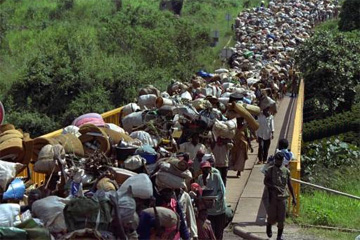
| Refugees pass through a "pinch point", in this case a narrow bridge. The Israelites would have looked like this as they passed through the Red Sea. |
If the number of the Israelites cannot be reduced - and I hope that the above has shown that the Biblical numbers deserve to be taken seriously - we need to look carefully at the problem of the "pinch points". Let us imagine a line of people one mile long. Each of the people is spaced exactly two feet apart, which means the line contains 2640 people. At a normal walking speed of 4 miles per hour, the entire line could walk past you in a quarter of an hour. That means that in an hour a line four miles long could walk past you - 10,560 people.
Just to keep the maths simple (and to make a token nod towards reality) let's reduce that to 10,000. If 10,000 people can walk past you in one hour, it would take ten hours for 100,000 people to pass and one hundred hours for a million people to pass. In other words, it would take 250 hours for the entire 2.5 million Israelites to walk past - and you would still have the animals to come.
Of course, the idea of the Israelites lining up to walk single file through the Red Sea is ridiculous. Obviously they are going to walk in a whole lot of lines. If we imagine 100 lines of people walking in parallel, then it would only take one hour for a million to pass and two and a half hours for the entire host of Israel to pass. If we allow three feet between the lines, that would require a front of 300 feet - which is not unreasonable. More to the point, the underwater ridge at Adabiyeh Point appears to be at least that wide and if we imagine that the sea level was lower in antiquity (which it was) and that the ridge had been built up by wind-blown sand (which is possible) then the difficulty disappears.
I certainly don't claim that the Israelites travelled in such a dense column all the time, but under the impetus of fear I see no reason why we should doubt that 2.5 million people could jog-trot the five and a half miles from one shore to the other in a reasonable length of time. Some, such as a mother and her children, would be bunched closer together, others might swagger along further apart. The elderly might shuffle and the children would scamper, driving their goats before them, but the last person would leave the Egyptian shore two and a half to three hours after the first person left it.
Incidentally, we need not worry too much about the herds and flocks. It is unlikely that slaves would be able to accumulate vast herds of animals and the pampered animals they had taken from the Egyptians probably died or were eaten during the journey to the Red Sea. If each family had half a dozen sheep or goats, a donkey or two and a cow, that would be typical of a Middle Eastern flock in the present day.
Mt Sinai
The Children of Israel marched across the Sinai desert and two months - 56 days - after leaving Egypt they arrived at Mt Sinai. Unfortunately we do not know how many of those days were travelling and how many were resting. Certainly they were not travelling the whole time: there was the battle with the Amalekites, the visit from Jethro, stays of various lengths at Marah and Elim and other oases. It is also probable that they refrained from travel on the Sabbath. However without knowing how many days were devoted to travel it is impossible to perform any useful calculation of walking speeds and distances covered.
| |
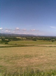
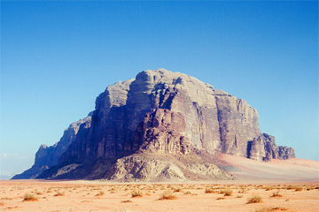
| Jebel Rum, showing the dramatic, isolated nature of the mountain and the wide plain that almost surrounds it. |
Various sites have been proposed for Mt Sinai: there is the traditional Mt Sinai, otherwise known as Jebel Katerina; there is Jebel al-Lawz in north-west Arabia; Jebel al-Madhbah (otherwise known as the High Place) in Petra; Jebel Ideid in the Negev; and Jebel Rum in Wadi Rum in southern Jordan, plus many others.
We need not concern ourselves with the Petra High Place; when Israel tried to pass through Edom the king of Edom came out against them with an army, so he is highly unlikely to have allowed them to camp undisturbed around a mountain in the middle of his capital city for nearly two years! Jebel Rum, illustrated here, is certainly dramatic enough but there is no particular reason to single this mountain out from many others in the vicinity equally as dramatic and the location seems unlikely. Jebel al-Lawz depends on a Red Sea crossing near Nuweiba and this I categorically reject (see the film referenced above for the reasons why).
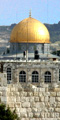
Having visited the traditional Mt Sinai several times I am emotionally inclined towards it, but there is a grave objection to it - two and a half million people, encamped for two years, must have left some trace of their presence. One would expect to find the desert littered with broken pottery and the Hebrew equivalent of "Kilroy waz 'ere" scratched onto the rock in a dozen places. Although there is a splendid plain in front of the mountain, large enough to accommodate the Israelites, there are simply no remains to be found, despite surface searches by several competent archaeologists. Thus, although my heart inclines towards Jebel Musa and Jebel Katarina, I have to reject them.
The only site which has revealed ancient remains is Jebel Ideid, where Emmanuel Anati discovered thousands of rock-cut graffiti, shrines and altars, and pottery in abundance. The only problem is that the remains all date to 2350-2000 BC which is long before Abraham by conventional chronology and the time of Abraham by the Revised Chronology. Although at a pinch we could claim that the final date of 1950 is imprecise enough to fit the Revised Chronology, I think that most Christians would be unhappy at the thought that Mt Sinai had been a sacred centre for four centuries before the Exodus.
In short, I find myself unable to wholeheartedly support any of the candidates so far proposed, mainly because of the lack of pottery evidence around the mountain.
The Tabernacle
The final area where archaeology has anything to contribute is in the building of the tabernacle. The amount of gold required for the various items of furniture seems extraordinary to us and in previous centuries has been used as an argument to show the fictional nature of the Exodus story. A little thought might have shown that such arguments were fallacious: after all, Tushratta, king of Mitanni, wrote to Pharaoh Akenaton to say, "Send me much gold, for gold is like dust in the land of my brother". Then in 1922 Howard Carter discovered the tomb of Tutankhamun and critics of the Bible suddenly realised that if the Egyptians could afford to bury that much gold, they would hardly have noticed the quantity taken by the Israelites!
| |
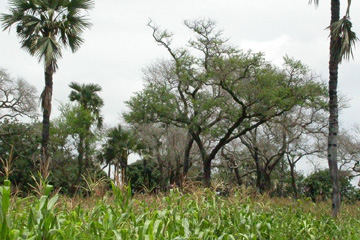
| Trees of the genus Faidherbia albida, formerly classified as "acacia", growing with palm trees and maize. |
The tabernacle itself was made of boards 2'3" wide and 15' long, which is a substantial piece of timber of any sort. Coming from the sort of acacia trees that grow in Egypt or the Sinai, it is a near impossibility. However the Egyptians were experts in using acacia wood, gluing short strips together cross-ply to make a sort of plywood out of which they constructed coffins and furniture. It is almost certain, therefore, that the Divine command to "make boards" rather than "cut boards" refers to the process of cutting up the wood that was available and gluing it together to create a plywood sanctuary.
| |
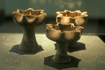
| Lampstands with seven spouts or wicks, found at Hazor in northern Israel. |
The seven-branched candlestick is usually depicted as a Jewish menorah and certainly the object removed from Herod's temple and carried in triumph to Rome - as depicted on the Arch of Titus - has that shape. However the original is described as beaten out of a talent of pure gold. Of course it is possible that the candlestick was made of several pieces - the stand forming one piece and the seven lamps individual pieces - but I venture to suggest that it would be impossible to create a menorah just by hammering at a lump of gold.
Excavations at Hazor revealed a number of lampstands associated with a shrine in the city. These were made of pottery and consisted of a bowl supported by a central pedestal, but each one had the rim of the bowl pinched to form seven "spouts" where wicks could be placed. These were indeed "seven-branched" lamps and the fact that all of them had seven spouts indicates that the number was not chosen at random. I suggest that the "seven-branched candlestick" produced by Bezaleel looked more like these lamps than like the traditional menorah.
| |
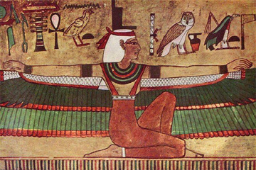
| An Egyptian representation of the goddess Isis. Is this a prototype for the cherubim? |
On each end of the Mercy Seat that covered the Ark there was to be a cherub "of beaten work". The Hebrew word cherubim is related to the Akkadian word kuribu, which refers to the winged bulls that are such a feature of Assyrian buildings. It may also refer (or be related to) the human-headed lions, winged or otherwise, that feature in Egyptian and Phoenician art - the sphinxes.
Over time it is believed that the wings became the important feature of these objects and eventually human figures with wings - the traditional angels - took the place of the earlier human-headed animals. In Western art angels have the wings sprouting from their shoulder-blades, like highly improbable birds, but in Egyptian art the wings took the form of feathers sprouting along the figure's arms.
| |
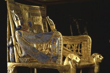
| Tutankhamun's famous throne has "cherubim" style armrests. |
We do not know exactly what the cherubim on the ark looked like, but they are unlikely to be the almost full-size human figures depicted in many artists' imaginative illustrations. The Ark was only 2'3" high and wide and 3'9" long, barely large enough for a single human-sized kneeling figure. When we consider that the Ark was supposed to be the throne of God, Who was seated on the Mercy Seat, it is easier to imagine the cherubim as arm-rests to that throne, somewhat similar to the arm-rests on the famous throne from the tomb of Tutankhamun.
Another indication of Egyptian influence comes from the fabric which covered the tabernacle. The outermost covering was of leather in order to make the building completely water-tight and proof agains the occaisional rain-storms that occur in the desert. The next layer was of coarse goats' hair cloth, the common material for beduin tents. This provided strength; if there were guy ropes, they would have been attached to this material. The inner-most covering was of fine linen dyed blue.
Egyptian tombs and temples frequently had blue ceilings, often with stars painted or attached to them. The idea was that although you were inside a building, you could - if your imagination was strong enough - think that you were still outdoors in the open air, under the blue of heaven. There were no stars in the Israelite tabernacle because the God of heaven was a God of light and day, not of darkness and night.
"Walls of the Ruler" The Story of Sinuhe is a rambustuous adventure tale of an Egyptian nobleman who flees the court for fear that he will be accused of assassinating Amenemhet I. He reaches safety in Palestine where he uses his civilised knowledge to become a chief among the wandering nomads there, but in his old age he pines for the comforts of Egypt and finally returns home on the invitation of Sesostris I. It's worth reading for its own sake (you can find the complete text on the internet) but of interest to us is his description of how he got past the border barrier.
I reached the Walls of the Ruler,
Made to repel the Syrians and trample on the nomads,
I took my shelter in the bush
For fear of being seen by the guard on the wall who was on duty
And made my way at night.
In other words, in best "Escape from Colditz" tradition, he lay hidden during the day watching the guards and working out their beat before slipping over the wall under cover of darkness. Return
Three tribes camped I have seen illustrations showing the tribal tents set out very much in British Army style and no doubt Bishop Colenso's strictures would apply. It is much more likely that the encampment was spread out over many square miles, probably with a mountain or two in between the tribal groups which formed a loose collection of tents straggling along a valley bottom. Return
Send me much gold This demand is echoed in the correspondence between Akhenaton and Burnaburiash of Babylon, who also wanted "much gold". The reason Burnaburiash gives for his request is interesting.
When my father and your father had dealings in good friendship, they sent each other beautiful presents, and nothing they refused. Now, my brother has sent me only two minas of gold. But this is a very small amount: send, then, as much as your father did! And if you have little gold, send half of what your father sent! Why have you sent me only two minas of gold? My work in the houses of the gods is abundant, and now I have begun an undertaking: Send much gold! And you, whatever you need from my land, write and it will be sent to you.
This compares with the request made by Solomon to Hiram of Tyre for cedar wood for the temple of God in Jerusalem. Return
2'3" wide These measurements are based on an assumed 18" to the cubit. The actual length of the cubit varied from place to place and over time, from 18" to 27". The ancient Egyptian "Royal Cubit" was 20.6" long and may well be the unit of measure used by the Israelites so soon after their departure from Egypt. Return