Tour 5 - East from Jerusalem
Inn of the Good Samaritan - Sea level - Roman Jericho - Tel es-Sultan - Mt of Temptation - Qumran - Ain Feshka - Engedi - Swimming in the Dead Sea - Masada - Sodom
Take the road down to Jericho, stopping briefly at the Inn of the Good Samaritan which has served as inn, police post and army checkpoint by turns. It is doubtful if the good Samaritan ever saw this place, but he would certainly have recognised the surroundings, which are as bare and desolate as any robber could wish. It is a rare trip when you do not see beduin tents near the road, with camels and goats grazing enthusiastically on bare dust while gamin and grubby Arab children play nearby. Don't stop too close or too long or they will abandon their games to come and plague you for bucksheesh, followed closely by their parents, whose demands will be larger and more pressing.
There is a band of reddish clay and sandstone near Jericho which gave the name to this road — Ma'ale Adummim — the Red Ascent. This name has been taken over with enthusiasm by the local Israelis and you will have noticed signposts nearer to Jerusalem, pointing to various "Adummims": Ma'ale, Kiryat, Kibbutz, Moshav and the rest.
Your next stop is likely to be at the Sea Level marker on the right. Jerusalem is about 2,400 feet above sea level while the Dead Sea is some 1,200 feet below. Your total descent is, therefore, equivalent to descending Snowdon in Wales. You are going down into the northern arm of the Great Rift Valley that runs all the way to Africa via the Red Sea. This whole area, which is known as the Wilderness of Judea, is so dry because it is in the rain shadow of the Judean hills. On the other side of the Rift Valley the hills of Moab have slightly better rainfall but the country to the east of them is also desert because they are in the rain shadow of the hills of Moab.
On the right you may notice a track leading off to Nebi Musa, which the Arabs venerate as the tomb of Moses. There is an annual festival and pilgrimage to the tomb. The shrine is a large mosque with multiple domes, but I wouldn't waste time making the detour. According to the Bible, Moses was buried on the other side of the Jordan, on Mount Nebo.
At the bottom of the valley you will come to a crossroads. The road ahead leads to a beautiful modern bridge completed in about 1965 and blown up in 1967 to prevent the Israelis reaching Amman. The only remaining bridge across the Jordan is the Allenby Bridge, a typical British army girder bridge. It too was blown up in 1967 but all that happened was that it crumpled in the middle and subsided into the water. Post-war photographs showed Arabs walking along the top girders to cross the river. Subsequently someone came along with a crane and fished the thing out again, put in a couple of new bolts and the bridge is back in business once more.
For security reasons, no vehicles are allowed across the bridge and into either country. (I believe that recently private vehicles not registered in Israel or any Arab country are allowed across.) Anyone wanting to cross the bridge has to board a special bus about half a mile from the bridge which transports them over the river and a similar distance into the other country. (The only exception that I know of — apart from UN personnel — was the cyclist Bettina Selby, who persuaded the border guards to let her through by the simple expedient of bursting into tears when they refused. It doesn't work for men.)
Whether coming or going, I have always found the Jordanian officials polite, dignified, courteous and helpful. I cannot say the same for the Israelis - though things have improved since the peace treaty, as civilian officials have replaced the arrogant and unpleasant army ones.
Note that Jericho is part of the disputed Palestinian Authority autonomous area. It would be wise to take advice before attempting to enter it. The advice which follows is based on visits made before the present intifada and may not be applicable today.
However, we are not going across the river. Turn left at the crossroads towards Jericho. About two miles down the road you will encounter an Israeli checkpoint. Large signs warn you to have your passport ready. Ignore them, they only apply to foreigners. Likewise if there is a long queue of trucks you should feel free to overtake them all at the first opportunity. As a tourist you will be waved through without difficulty. The technique in all these situations is to drive on confidently as if you own the place. Too fast, and you appear suspicious - those guns are loaded! If you are hesitant and slow you are a victim and will be stopped and searched. Smile sweetly, wave at the soldiers and don't stop unless specifically ordered to do so.
Turn left again before you reach the city and head along the modern bitumen road disappearing up a cleft in the mountain side, which is Wadi Qelt. The curious conical hill on the skyline to the left of that road is largely man-made (like the Herodion) and is a Herodian fortress called Kypros, after Herod's mother, who may be buried there. (Don't confuse it with the rather similar looking Israeli army post nearby.)
| |
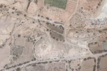
| Roman Jericho |
Shortly before you reach the cliffs there is a low mound on the right of the road. Stop the car and clamber up onto the mound, which contains the ruins of one of Herod's palace-cum-fortresses, built to guard the valuable balsam groves which Cleopatra so coveted. From the top you can look across to the other side of the wadi (a dry water course) and see the remains of Roman Jericho, the city which Jesus knew. The mound is visible in the photograph to the left, but this is one of Google Earth's worse pictures and you cannot really make out the other ruins which are just below the patch of green at the top of the picture.
On the other side of the wadi and to your left is another mound of ruins, which is the original Hasmonean winter palace. Just to its right you may be able to make out a large, rectangular hole in the ground, which was a swimming pool Herod excavated. More than likely it is the pool in which Herod caused his unfortunate brother-in-law Aristobulus, the last high priest of the Hasmonean dynasty, to be drowned.
I have not been down to these ruins so do not know whether or not they are worth visiting. If you can locate the main road through the Roman town you will probably be standing on a street which Jesus trod. No doubt if you engage one of the mendacious local guides he will be happy to point out to you the very spot where blind Bartimaeus sat and begged.
The road disappearing up into the cleft in the hills is the road which the unfortunate man who fell among thieves would have taken. It is possible to drive up to Jerusalem along the road, which joins the modern one near the Inn of the Good Samaritan. The road is narrow and the first couple of miles seem to consist of hair-pin bends, so be warned.
Since the intifada the Israelis have attempted to block this road just before Mar Girgis (ie. allowing access to Mar Girgis from Jerusalem but not from the Arab side) but the locals keep forcing a way through the blockage in order to reach Mar Girgis and other places. The status of the road thus varies from day to day.
As you start to climb you cross a swift-flowing stream in a culvert, which comes from perennial springs in the Wadi Qelt and originally supplied Herod's city with water. After a couple of miles you will see a large cross on the right of the road. This marks the start of a steep path down to Mar Girgis or the monastery of St George, an ancient monastery built into the cliffs of the wadi. (If you don't like the idea of the climb, it is possible to walk along a narrow path from Roman Jericho. The walk takes about 40 minutes.) A mile or so further a second cross marks a viewpoint from which the monastery can be clearly seen, dramatically clinging to the cliff on the other side of the wadi.
The monastery is supposed to mark the spot where Elijah hid from Ahab, and was fed by ravens. Another legend claims that St Joachim wept here for 40 days over the barrenness of his wife, until an angel came and announced the birth of the Virgin Mary. Although the monastery was first founded towards the end of the 5th century AD, the present building dates from the reconstruction in 1878.
(If you wish to follow this road down from Jerusalem you must turn left after the Inn of the Good Samaritan. Ignore the first turning right, a mere 20 yards later, but take the second, about three quarters of a mile further on.)
Herod's building programme covered quite a large area. Opposite ancient Jericho is Tel es-Samirat, the remains of a hippodrome and theatre Herod built to entertain himself and his courtiers. There is not much to see and anyway, Herod's hippodrome is not exactly vital to the Bible story.
Return to the main Jericho road and continue on into town. There will probably be another road block or a checkpoint, manned this time by smartly dressed members of the Palestinian police. Once again ignore queues and drove slowly through.
| |
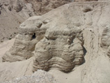
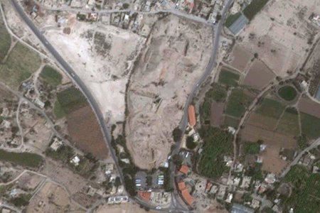
| Tel es-Sultan |
As you drive through the town take every opportunity to veer (not turn) left. This will bring you to a Y-junction. The right hand fork leads to a very pockmarked and weather-beaten tel, Tel es-Sultan, on the left of the road. There is a good car park and guides will clamour for your custom. If you are in the mood for fairy stories by all means engage one of them, otherwise try to make sense of the ruins on your own. There are a few meagre signboards, which may afford some guidance.
Climb the mound heading for the highest point on the left. You will come to a deep trench at the bottom of which is an impressive round stone tower. (This is about half-way up on the left of the tel as seen in the Google Earth picture on the right.) I once overheard a guide telling a family of Americans that this tower was Roman. "Gee, honey! (click click on the camera) Those little old Romans sure (click click) built a whole lotta stuff." In actual fact the tower dates back to the Neolithic Period and its sophistication should cause you to revise upwards your estimates of neolithic intelligence. When the tower was excavated Kathleen Kenyon found a number of skeletons at the bottom of the staircase that runs through the centre of the tower. She didn't speculate about them but it is tempting to picture them as defenders who had made an unsuccessful sally and were cut down as they crowded desperately into the tiny entrance to escape back into the city.
If you are facing the doorway at the bottom of the tower turn left and walk round the side of the trench, then look across the cutting to the north side. You should be able to make out a wall whose top is curved and collapsed outwards down the side of the tel. This, I believe, is the wall which Garstang identified as coming from the time of Joshua.
Head back towards the car park, climbing up to up to another cutting that runs roughly at right-angles to the car park. (It is at the bottom or southern end of the mound as seen in the picture.) On the further side of this cutting, the western side, look for a thick layer of pinkish ash, shaped rather like a tear drop tipped over 90° to the left. A man by the name of Garstang excavated at Jericho and found a wall which he dated to 1400 BC. This wall had been violently thrown outwards down the slope of the tel and the city behind it burned with fire. He identified this as the city which Joshua destroyed and his book makes quite dramatic reading if you can get hold of it. (If I remember rightly he even identified Rahab's house, an unburnt building on the city wall.)
The layer of ash you can see, however, is outside the city and if it has any connection with Joshua (which I believe it does), then it represents the contents of the city taken outside, piled up against the walls and burned. This is a more satisfactory explanation than the official one, which is that at some point attackers piled up wood outside the city and set fire to it. Baking mud brick does not seem a terribly effective way of weakening it, and although a blazing fire will certainly drive the defenders away from the wall, it will keep attackers away as well!
A few years after Garstang's excavations, Kathleen Kenyon also excavated at Jericho and using more up-to-date methods identified the ash layer as dating from the end of Early Bronze, about 2000 BC. In fact, she only found a scrap of floor, three wall bricks and a pot from the end of Late Bronze, the conventional time of the Exodus. She concluded that the story in Joshua must be a myth as there was no city at the time of the Exodus and therefore no walls to fall down.
In fact this is one of the archaeological problems in the Middle East. Palestine seems to have been virtually deserted at the end of Late Bronze and the beginning of the Iron Age, which is the period of the Exodus by conventional chronology. Ai had been uninhabited for 600 years, Jericho was little more than an unwalled farmstead, Heshbon was in ruins and Trans-Jordan an unpopulated wilderness.
What is worse is that there is no evidence of an invasion between Late Bronze and Iron. Although many sites show signs of destruction, the same culture continues unbroken from one period into the next, with the same architecture, the same gods and as far as we can tell, the same people. The only difference is that the Iron age people are considerably poorer than their predecessors. These uncomfortable facts have led many archaeologists to speculate that the Exodus may have been no more than a gradual migration of desert tribes who quickly adopted the culture of the people among whom they had settled.
It is a curious fact that Garstang's walls fit the Biblical account almost exactly. In their time Jericho was a thriving and important city which came to a catastrophic end. At this same time Ai was destroyed and never rebuilt. Nearly every site in Israel bears evidence of destruction and burning at the end of the Early Bronze Age, as also do many in Trans-Jordan. Furthermore the people who replaced the Early Bronze inhabitants had an entirely new and richer culture that shows distinct signs of Egyptian influence. They established a cultic centre at Shiloh, cutting out a rectangular platform that is almost exactly the same size as the courtyard of the Biblical tabernacle.
The only trouble is that they are 600 years too early to be the Israelites under Joshua. It is tempting to conclude that historians and archaeologists have somehow inserted an extra 600 years, a phenomenon which is not altogether unknown in the history of archaeology. The problem is to know from where we should remove these extra 600 years, but doubtless Petrie said much the same thing when he stuck the first dynasty of Egypt back around 5300 BC. Later historians cheerfully whittled out 2,000 years and quite possibly they will, eventually, drop another 600.
Go back to the Neolithic tower and this time head right - towards the top of the mound in the picture. On your right is a large depression which may be labelled "Garstang's Trench". This was dug by Professor Garstang in order to establish the stratigraphy of the mound and extends all the way to ground level. The sides are much fallen in through erosion.
At the extreme northern end of the mound is another cutting in which you can clearly detect the plaster glacis. Once again, this is supposed to be Hyksos. Yadin, in his book on warfare in the ancient east, points out that new defensive measures are a response to new weapons or methods of attack. Archaeologists believe that the Hyksos did introduce a new weapon — the chariot — but if that is so, what purpose did the glacis serve? As a means of attacking city walls a horse's nose is a fragile and unreliable instrument. Yadin believes that the glacis was introduced to defeat the newly invented battering ram. (Incidentally, he makes the same point about the much later change from casemate walls to solid walls. As it is most unlikely that the battering ram was invented twice, it just goes to show that even great men are not always entirely consistent!)
The Assyrians seem to have been the greatest exponents of the battering ram before the Romans so it would be interesting to know who used it before them. Certainly the threat must have been a very real one: you just think of the amount of work and expense involved in coating the whole side of this tel in hard lime plaster. Even today, with pre-mix concrete on tap, as it were, I wouldn't like the job!
You can photograph everything in sight, of course — cuttings, trenches, mud-bricks and ruined walls, but once you have the tower, the ashes and the glacis, that is basically it. The only other thing worth photographing from here is the Russian Orthodox monastery, clinging precariously to the face of the cliff on the Mount of Temptation. There is a cable car near Tel es-Sultan which carries pilgrims up to the monastery which seems odd to me. I thought pilgrimages were supposed to be uncomfortable and difficult? It only runs when it has customers. I have not used it or been up to the monastery, but I believe you have to make prior arrangements to have the contraption running.
Between the tel and the mountains is a refugee camp. Dame Kenyon found a number of Early Bronze tombs scattered among the huts, consisting of a shaft with a chamber off to one side. The interesting thing is that all these tombs were choked with silt, which Dame Kenyon interpreted as evidence that after they were built there was extensive deforestation, leading to massive erosion. The Bible records that when the Canaanites proved too strong for the Israelites, the Hebrews cut down the forests to clear land for farming. Are these silted tombs evidence of Israel's failure to conquer and further evidence for a different date for the Exodus?
Return to the car park, but turn left out through the ticket office arcade to the road, then turn left again and walk the short distance to the stream of water. This is known locally as "Elisha's Fountain" after the Biblical story of how the water was healed by Elisha. There is only one spring in this area and therefore this is indubitably the spring which Elisha cured by throwing salt into it. The water is cool and delicious (though with the insanitary refugee camp so close I wouldn't care to try it these days), proof that the cure was effective.
If you are interested, carry on down the road to the Hisham Palace, an Omayyid hunting lodge. Caliph Hisham was rather strait-laced so if the voluptuous clay statues in the Rockerfeller Museum are anything to go by, his nephew Walid ibn Yazid, a notorious womaniser and alcoholic, is the more likely builder. One man who visited Walid records how he found the caliph lying naked by a pool filled with wine. As he talked to him, Walid rolled over and into the pool, then promptly buried his face in the wine and drank so deeply that the man swore the level in the pool lowered perceptibly.
Go back to the Y-junction and turn left to the top of a rise. From here you can look back at the tel, framed by an abundance of palm trees, a reminder that Jericho was known in Bible times as "the city of palm trees".
The climb up to the 19th century Russian Monastery of the Temptation is long and arduous. You will be courteously received and the view (if the day is clear) is impressive, but it is doubtful if the expenditure of time and energy is worthwhile and the teleferique is a better option. Although monks have lived here from the 4th century onwards, it was only associated with the temptations of Jesus from about the 7th century. If you do go, be sure to leave a donation. Not many tourists make the effort and until the collapse of Communism, Russian pilgrims were few and far between these days. One has to admire monks like these for their devotion to what they regard as their duty, clinging on in poverty and discouragement during the dark years of atheism.
On top of the mountain is a new-looking stone wall. I have never climbed up there to investigate, but I am informed that the wall, which has been there as long as I can remember, protects various Byzantine remains. There should also be a Syrian fort somewhere up there, as Baccides fortified the summit when fighting the Maccabees.
Go back down the road. The modern Jericho is a rather grubby Arab town that is not worth visiting. The only reason tourists venture into the place is a very tall tree in the middle of a Y-junction. This is claimed to be the sycamore tree Zacchaeus climbed. As the lowest branch is 40 feet above ground level it gives you a new respect for the little man. Actually, the tree is nowhere near 2,000 years old so its only interest is as an example of a sycamore tree.
Nearby you will find a carob tree. Squeamish Christians kid themselves that the beans off this tree are the "locusts" that John the Baptist ate. Pick one of the pods if it is in season and imagine trying to eat that rock-hard, woody object. The fact is that locusts and grasshoppers are clean according to Leviticus 11 and undoubtedly are the creatures which John washed down with wild honey.
Go back along the road to Jerusalem, past the turn-off to Roman Jericho. The queues at both checkpoints are likely to be longer and slower moving and it would be wise to approach most carefully. Israeli soldiers tend to be trigger-happy, knowing that so long as the person they murder is not a Jew, they are unlikely to face any serious rebuke.
When you reach the main road turn left and a little later right to continue south and you will shortly see the turn-off to Qumran, a narrow road running steeply up to a little plateau on the right. There is ample parking at the top where the new visitor centre in modern Israeli style completely spoils the atmosphere of the place. The Essenes came here to be alone with God in the desert; they would be horrified at this ghastly cafe cum souvenir shop.
The buildings at Qumran are an Essene "monastery", though other interpretations have been put forward. Go straight to the central watchtower and get an over-view of the ruins before returning to ground level and examining them in detail. The items to photograph are the various cisterns with steps leading down into them, particularly the one whose steps were cracked by the earthquake of 31 BC and subsequently repaired; the water channel that supplied the cisterns; the communal dining room and the Scriptorium where the scrolls were copied. The writing desks which you didn't see in the Rockerfeller Museum are badly broken, indicating that they fell from an upper room when the place was destroyed in 70 AD, but at least it would have been over the room identified as the Scriptorium.
Jews in the time of Christ were divided into three major sects: Pharisees, Sadducees and Essenes. Sadducees stood for integration, attempting to marry Judaism with the best of contemporary culture and thought. As a result they were trusted by the Romans and given most positions of civil authority. Pharisees rejected anything gentile and stood for strict adherence to the Law, surrounding its requirements with countless interpretations and safeguards.
The Essenes also stood for strict adherence to the Law but believed that this was impossible in the contemporary world and for the majority of people. Instead they formed a community of the elect with strict moral standards and communal ideals, holding all things in common. Some withdrew to communes such as Qumran, others lived in society but kept themselves aloof; some allowed marriage for procreation, others held to celibacy.
These latter, in order to keep up their numbers, adopted orphans and particularly favoured the orphans of priestly families, whom they brought up in their way of life. John the Baptist, whose parents were aged at the time of his birth, may well have fallen into their clutches, which would explain why he was "in the desert" rather than among relatives in the hill country of Judea.
Josephus tells us that those who joined the Essenes bound themselves by oaths to keep apart from normal society, to the extent that they could not eat food prepared by non-Essenes, that is, someone not in the same state of ritual purity. Anyone who offended against the community's teachings or ideals was expelled, but not released from their oaths. Some actually starved to death as a result, others were taken back into the community when at their last gasp.
A characteristic feature of Essene life was frequent washing. Ritual immersion in a mikveh was practised by all Jews when they were unclean, for example, through contact with a corpse or following a woman's monthly period. Essenes went through this purification ritual at least once a day and usually more often.
If we can imagine John the Baptist becoming convinced that he should extend the blessings of this ritual washing to those outside the community, but without requiring any strict oaths of separation from the world, we can well imagine that he would have been expelled. Bound by his oaths but hardier than most, John survived on what he could find in the desert — grasshoppers and wild honey. Life must have been very difficult for him during his imprisonment by Herod; we can only hope that his disciples were allowed to provide acceptable food.
The bare area around the ruins is the graveyard. Over a thousand graves have been identified so far and the forty-one that have been excavated have contained predominantly male skeletons, only seven women and two children have been found. Most of them died before they reached forty. The graves are oriented north-south and contain nothing in the way of grave goods.
The reason why Qumran is famous today is the discovery in 1948 of scrolls dating back to the 1st century BC. Cave 4 or the Cave of the Wounded Partridge is to be seen in the white marl spur just to the west of the monastery. The other caves are scattered over the hillsides beyond and to the north of it and would require considerable time and effort to locate. Enquiries at the visitor centre (if you are determined) may or may not be helpful, depending on who is on duty.
A dirt road has been graded up the plateau towards the hills, all but destroying the remains of the water channel that brought water down from the wadi to the monastery. This is a piece of gratuitous vandalism by the Israelis for which those responsible cannot be too strongly condemned. When I was here in 1967 the stones of the channel stood out starkly against the untrodden hillside; now you have to know what you are looking for to find them.
Last time I was there a piece of wire stretched across the dirt road indicated that access was forbidden. It would be interesting to see who would try to stop you if you stepped across it. Being responsible for a group - and having been up there many times before - I didn't try the experiment.
Follow the channel as best you can. When you reach the cliffs you will find that the channel is now excavated from the rock and not long after disappears into a tunnel, through which you can crawl. The couple of holes eroded in the wall and floor of the tunnel are not really a danger to anyone. This will bring you out at the base of a waterfall which was dammed to form a collecting pool. Rain in the Judean hills sent water cascading down here half a dozen times every year and as much as possible was diverted to the monastery to supply those many cisterns and baths.
If, instead of retracing your steps through the tunnel you climb up and over the rocky knoll above it and follow the hillside round to the left you will come to a cave overlooking Qumran. As far as I know there is nothing significant about this cave, but if you squash yourself as far back in it as possible the mouth of the cave provides an attractive frame for a photograph of Qumran and the Dead Sea beyond.
Return to the main road and continue southwards, past the flourishing settlement of Ain Feshka. When I visited here in 1969 the ain was nothing more than a pool of sparkling clear water about twelve feet across and four or five feet deep, gleaming incongruously in the open desert. After swimming in the Dead Sea we were happy to rinse the salt off in this fresh water — where I trod on a snail or something and got its shell imbedded in my toe. Painful. Now, of course, there are little red signs up all along the coast warning you that swimming is forbidden. My guess is that the shore is mined against infiltrators trying to cross the Dead Sea but I am not anxious to test this theory by personal experiment.
The road south is fairly new. Until 1967 the border between Israel and Jordan ran down to the Dead Sea about half-way between Qumran and Masada and once you had followed the dirt track to Ain Feshka there was impassable wilderness (to say nothing of unfriendly border) as far as En-gedi.
As you drive along the road, notice the fringe of salt along the coast. The further south you go the more distant you are from the mouth of the Jordan and the supply of fresh water, hence the saltier the water. This has been exacerbated in recent years by the fact that most of the Jordan's water is now pumped overland to farms in the Negev. Whereas previously the Dead Sea maintained a precarious equilibrium between inflow and evaporation, it is now losing the battle. The result is that instead of being 30% salt, Dead Sea water is now 35% or 40% or even more, and the salt is starting to crystallise out where the water is shallowest.
In addition the shoreline is retreating as the lake dries out and is now 30-40' lower than it was a few years ago. The whole of the shallow basin south of Aba al-Lissan has now dried up and the level is still dropping. Huge dykes divide the former sea bed into salt pans which are supplied with water by a canal dredged along the bottom of the sea. Having known the unspoiled beauty of this area, I could weep, but I suppose that needs must when economics drive. (I can remember reading a book by a chap who walked down from Petra to Aba al-Lissan and caught the Dead Sea Mining Company ferry across to En-gedi. Happy days!)
For a long time people thought that Sodom and Gomorrah were drowned beneath the southern end of the Dead Sea. As the area is now dry and Israeli mining trucks rumble all over it, it would seem that this theory has been disproven.
More recently Ron Wyatt (now deceased) and Jonathon Grey claim to have located Gomorrah in the broken ground just to the north of Masada. They identify the salty white soil as "ash" and find tiny globules of sulphur in the soil, which they burn with a satisfying green flame - evidence for the "fire and brimstone" the Lord rained on the cities of the plain. In fact the globules are probably the remains of colonies of sulphur-producing bacteria which still exist in the area. If you find yourself in conversation with one of his followers, just ask where the broken pottery is - for that is the infallible sign of any ancient site.
If the Dead Sea is still there, you can swim in it at Engedi, where showers have been provided. These are a most necessary luxury. Two minutes out of the water and the salt is already crystallising visibly on your skin. Believe me, it will itch like crazy unless you wash it off.
Swimming in the Dead Sea is a novel experience. Getting some of it in your eyes or mouth is equally novel but far from pleasant. Keep your head well above water and do not be tempted to dive in! One year we came here in a coach driven by a Persian who spoke no English. Seeing us disporting ourselves in the water he went and changed and before we could stop him, dived most gracefully. He came out faster than he went in!
Another time my son Timothy happened to swim past some English people and he overheard one say to the other "They say that this water is very medicinal so I'm going to take some home." Suiting the action to the words the person filled a large bottle with from the sea and then, no doubt feeling that one couldn't start on such a good thing soon enough, raised the bottle to his lips and took a good swig. Next thing Timothy saw was the health-conscious one very firmly emptying the bottle back into the Dead Sea. Obviously health at such a price was too expensive!
If you have any cuts or abrasions you will very quickly be made aware of them. I am told that after a while you don't notice them, but I have never stayed in long enough to find out. The only good thing is that you need not worry about infection. There are no germs in the Dead Sea!
Be very careful about leaving valuables in your car while you are swimming. If you are with a friend one of you should remain by the car while the other swims. Most Jews are honest but to lose your exposed film at this stage of the game would be heart-breaking. Anyway, someone has to take the traditional picture of you reclining on your back in the sea while reading a newspaper or guidebook. Don't try it with anything valuable. For some reason your feet float higher than your head and it is surprisingly difficult to maintain an even keel.
Masada is a fairly distinctive shape looming out of the Judean hills on your right as you travel south, but in case you fail to recognise it, the bustling car park, visitor centre and cable-car are a dead give-away. The only advantage of the cable-cars is speed and ease; the climb up the Snake Path is arduous and exhausting and will take you at least an hour whereas the cable-cars can have you on the summit in three minutes (plus an hour in the queue at peak times!)
WARNING. If you do decide to walk make sure that you take plenty of water — three litres is not excessive — as the supply at the top is not reliable and tastes awful. In an atmosphere as dry and hot as here your perspiration evaporates immediately so that you do not realise how much water you are losing. Drink plenty: sun-stroke, nowadays known as "heat exhaustion", is neither more nor less than dehydration. You can die from it, yet it is totally avoidable. Plain water is the ideal beverage as sugar acts like salt to make you thirstier.
There is a restored Roman fort just outside the visitor centre. Most tourists pass it by without notice, but a photograph or two would no go amiss. The visitor centre offers lots of information and a film about the heroic defenders of Masada but strangely omit to mention that the only offensive action they ever took was to raid Engedi and slaughter several score of fellow Jews. The Romans who attacked them were, if you like, acting to defend the Jews against the fanatics in the fortress.
For some stupid reason Masada officially shuts at 3.30 pm. I must admit that if I arrived after that time I would be inclined to climb up anyway. If the Romans could get in when the Jews didn't want them to, why can't I? If, like me, you suffer from vertigo, I am happy to assure you that the cable cars do not crash into the cliff-face. If you have your eyes closed, it is only fair to warn you that as you pass the supporting pylon there will be a sickening lurch. The floor is not about to fall out.
Visitors inevitably head straight for the northern palace with its three terraces and you should do the same. Notice the magazines or storehouses before you reach the palace; most have been restored and the black lines painted all over the place indicate the height of the surviving walls before restoration. A couple have been left as the excavators found them, to give you an idea of the work that has been done up here.
The lowest terrace of the palace villa is a Roman bathhouse, complete with hypocaust for heating, a feature that you may think was superfluous if your visit is in summer! Here the excavators found three skeletons, a man of about twenty, a child and a young woman with perfectly preserved hair. The plaster beside her was stained with blood. These were obviously a little family group who had committed suicide together but on their own, apart from the others.
Near the northern water gate the excavators also found eleven small pot-sherds, each one inscribed in the same handwriting with a name or nickname, including the name Ben Ya'ir, the Jewish commander of Masada. Were these the lots by which the final man was chosen to kill his companions - who had already killed the other 950 people - and then commit suicide himself, perhaps down beside his wife and child in the lower bathhouse?
From the palace be sure to trace and photograph the Roman siege wall and camps in the valley below. The wall was constructed to ensure that no supplies or messages got into Masada and none of the garrison got out. The main Roman camp seems to have been up on the higher ground to the west of Masada and you can make out its ruins quite clearly from this height.
Return along the western side of the summit, taking every opportunity to peer down at the ramp built by Jewish captives to raise Roman siege engines to the level of the wall. This posed a nice dilemma for the 960 defenders of Masada: should they attack their fellow Jews who were building the ramp, in order to preserve their own lives and independence? The mound at the bottom has been raised both as a memorial to the defenders and as a site for army ceremonies. All recruits to the Israeli army are brought here to take the oath "Masada shall not fall again".
When you reach the western gate you are faced with a dilemma of your own: should you go down the ramp in order to photograph Masada from the west and explore the Roman camp? The views are certainly dramatic and give you a unique understanding of the work involved in capturing the place. On the other hand you would really need to climb quite a way up the road on the other side in order to fit it all in so unless you have plenty of time and lots of energy the descent is probably not worth while. Even the Roman camp, which was General Silva's headquarters, is not worth it. On the ground the walls which are so clear from above become a confusing mass of fallen stone and there really is very little to photograph. I climbed down to the camp to make the film "Finds or Frauds" (available from this website) and was most disappointed at what we found.
If you do go down, notice two lines of cave mouths in the cliffs to the left of the ramp. In fact these are cisterns which were supplied by aqueducts and it is possible, if you have a head for heights, to scramble along the remains of the water channels and into them. What amazes me is how the people up above were able to get at the water once it was in the cisterns. There must have been stairs or ladders which have since vanished.
Incidentally, don't attempt to go back down to the visitor centre from here by skirting round the mass of Masada. In both directions the valleys end in waterfalls. There may be paths down which one can scramble, but I have not tried them nor have I been able to pick them out from above.
Continue south along the wall, detouring towards the centre of the plateau to find the "columbarium". The niches inside are small and shallow and totally unsuitable for pigeons, so the alternative suggestion is that the building was intended to hold the ashes of those who died. Neither theory is particularly convincing.
Further south but still towards the centre of the plateau is the southern cistern, a huge hole in the ground into which you can climb. If you are fortunate enough to have the sun beaming in through the hole in the roof at the far end you will have a dramatic and striking picture.
At the southern tip photograph the ravine and the Roman siege works and then turn north along the eastern wall, noticing the fact that this is a casemate wall - a double wall divided into rooms in which the garrison lived or stores were kept.
Keep a close eye out for the mikveh set in the casemate wall just past the southern water gate. It consists of a main pool into which water could flow from a smaller reservoir, controlled by a wooden peg in a hole. Ritual immersions had to be performed in running water, which makes sense when you consider that God intended this all-over wash in running water as a means of preserving health.
The rabbis spent considerable time debating the matter and finally decided that "running water" was water which had not been carried. Similar debate settled the issue that a small quantity of pure "running water" could make pure a larger quantity of non-"running water".
Consider the matter as intended by God: a butcher who has just slaughtered a hairy old bullock and is covered in blood and excrement, an old crone who has just finished laying out a smallpox victim, and a blushing young mother who has just come to the end of her monthly period and wants to make herself nice for her husband. In turn they go down to a stream of fresh, running water and wash themselves and their clothes. They return home clean, fresh and healthy.
Now consider the result after the rabbis had been at it: the same three enter a pool of green, stagnant water that has been sitting there all summer. (There is, in the ruined crusader hospital near the Western Wall, a couple of ancient mikveoth of precisely this description, so I'm not joking.) Each one lets in about a cupful of "running water" and then immerses him or herself in the now ritually "pure" water. Would you be surprised if I suggested that the young mother and her children shortly thereafter died of smallpox? No wonder Jesus condemned the Pharisees and declared that "by your tradition you make the commands of God of none effect".
That is not the end of rabbinic scruples, however. Women going through the ritual of the mikveh have to make sure that the "purifying" water touches every part of their bodies. Not only do they have to be naked, but even band-aids have to be removed. Fair enough, you might say. However when you learn that any scabs have to be picked or scratched off — and some ultra-Orthodox women actually have the fillings removed from their teeth — you begin to see how these rules and regulations have totally nullified God's intention and, like the Sabbath laws, turned what should have been refreshing and enjoyable into something restrictive and burdensome and at best pointless, at worst actually harmful.
If you came up by cablecar you may wish to walk down the Snake Path, which will take about twenty minutes unless you are foolish enough to run. Be sure to explore the restored Roman siege camp near the car park.
Sodom (Sedom) is a modern settlement established to exploit the mineral wealth of the Dead Sea. When I visited in 1958 I was shown a rock pillar about 20 feet tall towering some 60 feet above ground level; nearby was a cave into the salt-impregnated cliffs. The pillar was jokingly identified as Lot's wife. Last time I was there the pillar had fallen (another has been picked out for the benefit of tourists) and the roof of the cave had collapsed.
Even worse, the level of the sea has dropped so much that hotels built on the shore now have board-walks reaching out to the water's edge a quarter of a mile away. In short, the place is not worth a visit apart from the swank of being photographed leaning negligently on the town sign — and even that goes missing from time to time, purloined by someone who wants that extra special souvenir.
If you have not already visited Beersheba this may be the best time to explore the Negev, otherwise return to the north.