Qumran Caves
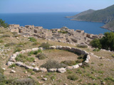
Khirbet Qumran stands on a plateau about 100 feet above the plain surrounding the Dead Sea. There is a modern visitor centre with a minimum of information and a maximum of ice-cream, soft drinks and tacky souvenirs, outside of which are the 2,000 year old ruins. Once you have explored them, turn your back on the ruins and identify the double line of stones which marks the course of the channel that carried water down from the waterfall at the head of the wadi beside Qumran.
Cave 1 is about 1,000 yards north of Qumran, at the top of the first stage of the rocky ascent from the plateau. After crossing the first main wadi north of Qumran, keeping to the track that runs beneath the cliffs, you will come upon the circles of stones marking the site of the camp of the 1949 excavators. A little further on there is a large boulder standing on its own in the flat area to the right. Look left where you will see another at the foot of the cliffs. Take a bearing through these two rocks and walk toward the cliffs to a heap of tumbled shale which is the beginning of the climb. Continue straight up from there and you cannot(!) miss the cave on the right, behind a pinnacle of rock.
Caves 2, 3 and 11 are in this same area, one to three kilometres north of Khirbet Qumran.
Cave 4 (the Cave of the Wounded Partridge) is just to the west of the monastery buildings and can be clearly seen in the headland jutting out parallel to Qumran. The hole in the top is the one by which the Beduin gained access to the cave, the holes in the side were either created or enlarged by them to facilitate the work of clearing the cave before the Jordanian Antiquities authorities stopped them.
Caves 5 and 7-10 seem to have disappeared. Cave 7, where what may be a cache of Christian documents was found, has been eroded away but in other cases forgetfulness may be to blame. There is nothing much to distinguish one hole in the rock from another in this wilderness.
Cave 6 is just below the path to the tunnel through which the water was conducted down to Qumran. You used to be able to spot the triangular opening from the point where the double line of the aqueduct vanishes. Since the Israelis have vandalised the line of stones it is hard to tell where this critical point is now.
It really is too bad that the visitor centre is solely concerned with making money out of the tourists. They ought to mark out a visitor trail - perhaps call it the "Mohammad ad-Dib Trail" - leading to all the visible caves, with viewpoints and notices remarking on the vegetation and wild-life along the way, as well as detailing what was found in each cave. It does not appear to have occurred to them that the longer people spend out in the open down there, the thirstier they become and the more likely they are to purchase ice-cream and soft drinks.