Ron Wyatt and Pharaoh's Chariot Wheels
| |
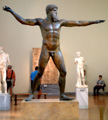
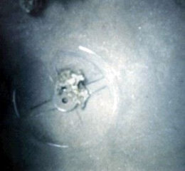
| One of pharaoh's chariot wheels, according to Ron Wyatt. |
One of the more audacious of Ron's claims is that he has discovered the wheels from Pharaoh's chariots lying on the seabed off the port of Nuweiba. For example, the caption to the picture shown here states, "Coral-encrusted chariot wheel, filmed off the Saudi coastline, matches chariot wheels found in Tutankhamen’s tomb." This is an out-and-out lie. (If you want to check that this is really the claim, click on the word "caption".)
This claim is made in support of Wyatt's contention that the Children of Israel crossed the Red Sea right the other side of Sinai, at the port of Nuweiba in the Gulf of Aqaba. There are many possible locations for this crossing, but Nuweiba is definitely not one of them! However before we get into that, let's deal with this chariot wheel.
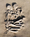
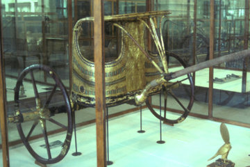
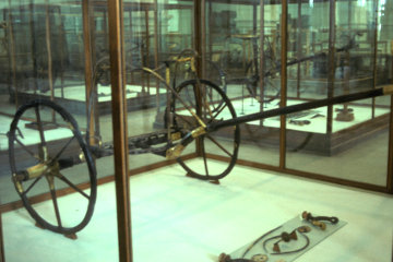
Needless to say, I have visited the Cairo Museum many times and although I wouldn't claim to be an expert on Tutankhamun, I am very familiar with the treasures from his tomb. Among the items on display are two chariots, which are reproduced below.
| 
| |
| Chariots from the tomb of Tutankhamun in the Cairo Museum | ||
I would like you to notice the wheels on those two chariots. Note the number of spokes; note the thickness of the rims; in particular, note the elongated boss on the outside of the wheel. Now compare those three features with the wheel in the picture. Real chariot wheels were made as light as possible and the rim consisted of a piece of wood bent into a circle. Because it was so light and fragile, it needed to have more than four spokes, but they too were made as light and thin as possible.
I have no idea what the wheel in Wyatt's picture is - I suspect it is a piece of machinery and is made of iron - but to claim that it "matches chariot wheels found in Tutankhamun's tomb" is a lie, pure and simple.
| |
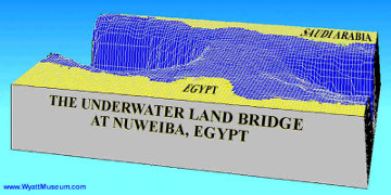
| Wyatt's claimed underwater land bridge, from Nuweiba across to Saudi Arabia. |
And while we are dealing with lies, I invite you to study this picture, taken from the Wyatt Museum website which purports to show how the Israelites crossed the Red Sea at this point. The trouble is that maritime maps show that in the area of Nuweiba the Gulf of Aqaba is 765m deep - that's nearly 2,300 feet deep! If the Red Sea was opened by the strong wind sent by God - which is what Scripture implies - imagine the strength of the wind required to move 2,300 feet of water! Just for comparison, Hurrican Katrina, which caused a tidal surge that devasted the city of New Orleans, managed a swell of 32 feet.
So Wyatt gets round this minor difficulty by claiming that there is an underwater land bridge between Nuweiba and the Saudi coast, which is depicted the picture from his website.
Once again, Google Earth is our friend. Start up Google Earth and type "Nuweiba, Egypt" into the search box at upper left. After you are flown to the location, zoom out (using either the wheel on your mouse or the PageUp and PageDown keys on your keyboard) until you can see both sides of the Gulf of Aqaba.
One of the features of Google Earth is that as you move your mouse over the map, down at bottom right you get a constantly changing number labelled "alt" - for "altitude". Try moving your map over the land and watch how the number increases as you climb up away from the coast and onto the rugged hills of the Sinai plateau. Now move your mouse over the water and watch how the numbers turn negative to indicate depth below sea level. Can you find this land bridge?
You should have no difficulty. Although Google Earth does not plot every square inch of earth's surface, my understanding is that they plot a point every 90 feet - that is, a grid is made of points 90 feet apart. (In some places the figure is even better, down to 50 feet or so). So it is possible that this underwater land bridge may follow a particular course that winds between the points plotted by Google Earth, right?
What it DOES show is a swatch of sea floor from Nuweiba across to the Saudi shore, which is much shallower than the sea on either side of the underwater land bridge. This swatch of sea floor is roughly between 7 and 10 miles wide.
http://www.wyattmuseum.com/red-sea-crossing.htm
Did you know that you can tilt Google Earth maps? Use the Shift key plus the up-arrow key and the down-arrow key on your keyboard to tilt the map. This will enable you to look along the Gulf of Aqaba. Can you see this land bridge? Oh, and once you have found it, don't forget to respond to the appeals for money on every page of the Wyatt Museum website. Does that tell you anything about the motivation of these people?
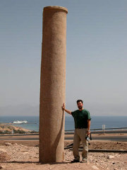
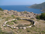
| |
| Wyatt claims that this pillar was erected by Solomon to commemorate the crossing of the Red Sea. |
However it would not be right of me to close my treatment of this subject without reference to the crowning proof that the Israelites crossed the Gulf of Aqaba at this point. This is the "Phoenician-style" column at Nuweiba erected by King Solomon to commemorate the crossing. There is - so we are told - a matching column on the other side of the Gulf, also erected by Solomon.
I have chosen this picture, from the website of a Ron Wyatt disciple rather than the one on the Wyatt Museum website, simply because it shows the "Phoenician" features of this pillar rather more clearly. Notice how the pillar is very round, indication that it has been turned on a lathe. Then notice that it is wider at the base than at the top and swells slightly in the middle, a feature called entasis which was invented by the Greeks some six centuries after Solomon, but no doubt Solomon, being the wisest of all men, got there first but was just to modest to mention it. Finally, note that there is a lip at the top of the pillar.
Once again I invite you to go to Google Earth. You can type in "Byblos, Lebanon" in the search box or you can enter the coordinates 34 07 08.39N 35 38 48.08E, which should bring you down right over the Obelisk Temple. There are at least four photographs of this temple, all of which show you what Phoenician pillars looked like - they look like obelisks!
However if you hunt around, you will find just on the northern edge of the Obelisk Temple a photograph labelled "Roman columns of Gebal". Have a close look at those Roman pillars, please. Do you notice anything familiar about them?
Now it is certainly true that some of the people who post photographs to Google Earth are careless about where they place the pictures and some are apallingly ignorant, so let's look elsewhere, this time at the city of Scythopolis, better known as Beth Shan, just south of the Lake of Galilee. All the extant ruins are Roman, so there is no way that a photograph could mislabel them. Any picture is going to show something Roman. Copy and paste these coordinates into Google Earth: 32 30 07.11N 35 30 01.95E This should bring you down right over the picture I want, but if it doesn't, it will be nearby, at the south-east corner of the bath house. The picture is labelled "Beith Sheai - Roman Ruins". Have a good look at the columns: round, swelling in the middle, narrow at the top, with a distinct lip beneath the capitals.
I won't waste you time with talk of the "Egyptian fort" constructed by pharaoh, which is so clearly Turkish that words fail me. I will merely conclude by pointing out that if the Israelites had crossed the entire Sinai peninsula in the short period allowed by the Bible from their exodus to their arrival at the Red Sea, they would have had to be droving jet-propelled sheep and Moses would have needed to bring water out of the rock long before he did.
On a more reasonable speed, by the time pharaoh heard that they were trapped beside the Red Sea and equipped his army for the arduous desert crossing - and I've done it a couple of times and can testify that there is nothing there but hot, dry sand - the Children of Israel would have been long gone!