The Gleaming Mountain
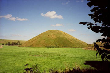
| 51 24 56.26N 1 51 27.58W | Silbury Hill | This is one of the better pictures on Google Earth, with so much detail that you can just about make out individual blades of grass. Unfortunately the contour mapping is too coarse and you don't get to see the hill in 3D when you tilt the picture. |
| 51 25 42.88N 1 51 14.95W | Avebury | So close that you can see both from an eye altitude of 13,000 feet, Avebury is an amazing circle of banks and standing stones. Look at some of the Panoramio pictures for an idea of what the place looks like from ground level. |
| 51 24 30.90N 1 51 03.27W | West Kennet Long Barrow | Standing on the top of a ridge, the barrow is a landmark visible for miles around. |
Motorways are, doubtless, a fantastic way of getting from A to B as fast as possible. If you want to travel from London to Bristol and points west, the M4 is certainly your first choice of route - but I am glad that I first made the journey in the days when bulldozers were only just starting to tear up the sods and gouge cuttings through ancient chalk. I had to follow the A4 - and what a fascinating experience that was.
|
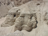
| Silbury Hill as it appears today. |
Some months previously we had made a tour of the famous pre-historic sites such as Stonehenge and the Avebury Circle, so when we saw the sign pointing off to Avebury we ignored it and continued straight along the road. Three-quarters of a mile further on, however, we came to a screeching halt in a layby on the right-hand side of the road, where we sat gawping at the enormous cone of Silbury Hill.
In those days there was a somewhat less than informative information board in the layby and a plethora of red signs along the wire fence that separated the road from the field, warning trespassers that the land beyond the fence was "Private" and that those who ignored the notice would be persecuted. (Given the state of English law on the subject of trespass, prosecution is not a realistic option for land-owners.) The information board told us that the hill was a protected ancient monument, the largest pre-historic man-made structure in Europe, and it was forbidden to climb the monument.
I duly took a single photograph - those were the days when pushing the button on your camera cost you a shilling or so for film and processing; how different things are in these digital days! - and we resumed our journey to Bath.
Back in those happy but primitive days, there was no such thing as Wikipedia and the resources of our local library did not extend to ancient monuments fifty miles away. Enquiries among friends and acquaintances revealed that the hill was an ancient burial mound and a place of druidical worship and a Norman castle mound and a total mystery that no one could explain - and with those conflicting explanations we had to be content.
Over the years, however, I have eagerly fastened onto every bit of information I could find about the mystery monument beside the A4. Apparently the first investigation of the mound was done in 1776 when the Duke of Northumberland sent a team of Cornish miners to dig a shaft down from the top of the mound. Whether his grace was athirst for antiquarian knowledge or hoped to find treasure, I am not sure, but he was disappointed on all counts, for his workmen found nothing.
A century later somewhat more reputable investigators dug a tunnel in from the edge of the mound to the centre, but they were equally unsuccessful and found nothing of any interest. Even Sir Flinders Petrie, who investigated Silbury Hill after the First World War, was unable to provide a solution to the mystery of who created the monument and why.
In the meantime the hill has been expertly surveyed and found to be 130' high, with a base diameter of 548', rising to a flat top 98' in diameter. The hill was built with a precision that, for the time, rivals that of the Great Pyramid of Gizeh, for the centre of the flat top and the centre of an imaginary cone formed by the hill are less than 3' apart!
The hill was formed by heaping up 324,000 cubic yards of earth - which, for those who like homely comparisons, means about 32,400 average sized dump truck loads - all piled up by hand. If we pick a workforce of 500 men (or women), then the hill must have taken around fifteen years to complete!
However the time taken was probably much greater because excavations in 1968-70 discovered evidence of three separate stages in the construction of the monument.
In the first stage a circular wall of sarsen stones was constructed, within which turves and gravel were heaped up to form a mound. In the second stage a ditch was dug outside the sarsen stones and there is evidence that the ditch was allowed to fill with water - though whether this was to beautify the site or to defend it we do not know. Chalk rubble from the ditch was heaped onto the mound of gravel, raising it higher. In the third and final stage, more earth and rubble was brought from elsewhere (no ancient quarry has been identified) and heaped up to make the present mound, which is so big that it completely covers the ancient ditch and the ring of sarsen stones.
It was this final stage which created the ring or step around the top of the mound. Some have suggested that it was intended to prevent slippage - though I have yet to find a coherent explanation of how it would do that! - while others claim that it is the remnant of a spiral path that wound around the hill, though the absence of any sign of such a path lower down rather disproves that theory. My own theory is that it marks the position of a timber palisade around the top and possibly dates from a much later period - possibly the Norman, when motte and bailey castles were all the rage. Certainly the archaeologists have found mediaeval post holes that could be evidence of a large building, while the discovery of two arrowheads from the time of the Norman Conquest indicate that the hill may have been involved in fighting.
Unfortunately each of these investigations resulted in another tunnel being bored through the hill and none of them troubled to fill in the tunnel when they had finished with it. In the end Silbury Hill came to resemble a cone of Swiss cheese and under the benign influence of the British climate the hill began to collapse into the holes and tunnels. In 2000 a large hole appeared in the top of the hill, presumably connected in some way with the activities of the Cornish miners.
Alarmed, English Heritage undertook a major programme of restoration and rennovation, bringing in hundreds of tons of chalk with which to plug the tunnels. The work, which ended in 2008, provided an opportunity for further study of the hill.
Among the discoveries were Roman remains on platforms on the side of the hill. It has long been known that the Romans used the hill as a surveying point, for the Roman road from London to Bath - the precursor of the A4 - runs in a straight line almost up to the hill, then swerves around it before running in a straight line away from the hill. This proves that Silbury Hill predates the Roman Occupation, but also indicates that the Roman road builders aimed for the hill as they approached across the plain and used it as a reference point as they headed away towards Bath.
The archaeologists also found the pieces of deer antler - probably used as primitive picks for digging in the earth - which they carbon dated to around 2,600 BC. This would put it in Britain's Neolithic period and if so would be yet another indication of just how sophisticated these supposedly primitive people were. Work in the tunnels shows that the underlying form of the hill is a series of drums, each about 17 feet high and built with an angled exterior wall (probably for stability). The drums were built with radiating internal walls, which were then filled in with chalk rubble.
In other words, the techniques used are very similar to those used to create the Step Pyramid of Saqqara, but adapted to fit the materials available on Salisbury Plain.
|
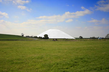
| Silbury Hill as it must have looked 4,000 years ago when it was first built. |
Perhaps the most surprising discovery - or should that be, realisation - came when the archaeologists realised that when it was first built, Silbury Hill would have formed a massive mound of white chalk. On a sunny day, it would have shone like a beacon against the dark green of the surround grassland. We can gain some idea of the impact this would have had on passersby by looking at some of the chalk figures elsewhere in southern England - the White Horse of Uffington or the Cerne Abbas giant. Here, however, instead of a white figure cut into a natural hill was an entire white hill standing starkly on the landscape.
Whether it was a tomb or a temple, a statement of power or of piety, there is one thing certain: in its day it must have been one of the wonders of the world and travellers who came upon it stood and gaped with astonishment at this mighty creation of man's hands.
found nothing A letter written by a certain Edward Drax has recently been found in the British Library. In it Mr Drax records that the miners did note a "perpendicular cavity", 40' deep and 6" wide, in which were some fragments of wood that were thought to be oak. It has been suggested that this was an oak totem pole or flag staff or something of like nature, but I must admit that I find that unlikely. A piece of oak 40' long is quite a substantial lump of timber; I have a feeling that a straight piece of oak 60' long would be about as long as you could get - but that would only leave 20' protruding out of the top of the hill. No doubt the builders wanted to be certain that their totem pole would remain standing, but burying two-thirds of it must have struck even primitive man as excessive!
I am quite willing to concede that the hole once held a 40' length of oak (or several lengths totalling 40') as otherwise the hole would not have survived the millennia, but I think it more likely that the oak had been bored to form a pipe by which communication or offerings could be transmitted into the earth. Return
My own theory As noted elsewhere, the way in which the hill was constructed from separate drums provides another explanation for the "step". However we believe that the hill originally had a rounded top or possibly even extended up to form a cone, but the top was levelled, probably to create room for a castle. There is, of course, nothing to stop both being true: the "step" marks both the top of a drum and the location of a wall or palisade. After all, there must be some reason why only this top-most drum has formed a step. Return
the techniques used If you want more information about Silbury Hill and the nearby monuments, the Avebury website is an excellent resource. Return
© Kendall K. Down 2010