The Disappearing Aqueduct
| Crocodile River | 32 32 55.61N 34 54 55.86E | The photographs associated with this location clearly show the dam and the mills driven by it. |
| Caesarea Aqueduct | 32 30 44.25N 34 53 47.49E | This is the modern end of the aqueduct, which can be traced northwards, buried in sand, until it turns sharply east and disappears among the houses of Jisr az-Zarqa. |
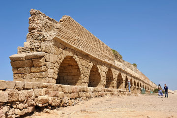
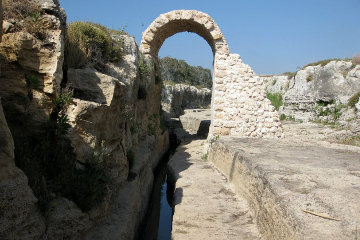
Once we have explored the ruins of Caesarea, we get back in our bus and drive half a mile north, stopping in a sandy car park with the blue waters of the Mediterranean visible thirty yards away. In the foreground rise the stout arches of what is clearly an aqueduct that must have carried water to Caesarea in Roman times but which now ends abruptly in jagged ruin. So many people have clambered up the rocks - and, presumably, damaged them as they did so - that the authorities have erected wooden steps and a viewing platform so that you can climb up and look along the two channels that once carried water from the foothills of Mt Carmel to Caesarea.
| |
| The broken end of the aqueduct half a mile north of Caesarea Maritima. |
If you look along the aqueduct - as I do every time - you can see it disappear into the sand, but its line is clearly marked by a dead straight sand dune heaped up over the ancient stone. When we return to the coach and head north along the motorway I always keep my eyes strained for any sign of the aqueduct on either side, but in vain. Somewhere between the beach and the mountain it completely disappears.
When I discovered the wonders of Google Earth the mystery of this disappearing aqueduct was one of the first things I investigate. Sure enough you can trace the line of the aqueduct - and see clearly how it is all but buried by the encroaching sand - for a mile and a quarter. Then you can see where it bends sharply to the north-east, but after a third of a mile it disappears among the crowded buildings of Jisr az-Zarqa and does not emerge on the other side. Very frustrating.
I was delighted, therefore, when I found more information about this aqueduct in a most unlikely place, an old book called The Land and the Book by the Rev W. M. Thomson DD. I have had this book for some years but am only just now getting down to reading it because it is really a most tedious piece of literature.
| |
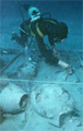
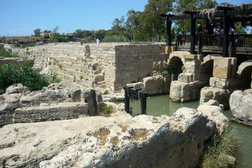
| The mouth of the Crocodile River, with part of an ancient bridge that once spanned the river. |
The book takes the form of a journey over the land of Palestine, from Lebanon in the north down to Hebron. Allegedly the Rev Thomson, who has been a missionary in the Lebanon for a couple of decades, is showing an American acquaintance the Holy Land and the two converse as they travel. The acquaintance asks a series of fortunate questions and the Rev Thomson answers at length, showing how the places and customs of Palestine illustrate and confirm the stories in the Bible.
Unfortunately the reverend gentleman has never heard of marks of quotation nor of varying the "voice" in which he writes, with the result that it is impossible to tell with any certainty whether you are reading a dumb question or the learned reply. In addition, Mr Thomson may be an acute observer of local customs and a reliable guide to current nomenclature, but in matters archaeological he is woefully misinformed. (Or perhaps it is that knowledge was not perfect in those days, for the book is set in 1857 when the exploration of Palestine was in its infancy.)
For example, he commonly refers to Crusader work as "undoubtedly ancient Phoenician" and his ideas of how Galilee and the Rift Valley came into existence are positively cringe-worthy.
Having said that, he does know the countryside. He was involved in relief and rescue work following the disasterous earthquake of 1837, and most curiously, he was called upon to bury Lady Hester Stanhope, the English eccentric who travelled out to Palmyra and in the end believed that she was a sort of John the Baptist for a coming Messiah. (http://en.wikipedia.org/wiki/Lady_Hester_Stanhope)
This is what he has to say about the aqueduct of Caesarea.
| |
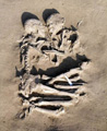
| If this arched covering ran the length of the ditch it would support the local claim that one could ride a horse through the aqueduct. |
But it is time to seek our tent at Towahin ez-Zerka, an hour to the north-east of us. Let us follow the line of these lofty canals - two in one - by which we shall obtain a better idea of the ancient suburbs and likewise observe the great size of the aqueducts, which were carried along parallel to the shore for about two miles. They served as a defence against the sands of the sea and the whole space on the east of them seems to have been occupied with buildings. We can see into the covered canals in many places and the stories of the natives, that a man could pass inside of them on horseback from the city to the mills of Zerka, do not seem to be incredible fables. They are in such preservation that it would not cost a large sum to clear them of the sand and again bring the water to the harbour. It is not true, however, as some travellers assert, that ships frequely put in here to obtain water from these aqueducts, for they have been broken for many centuries. Boats often call in summer to load with stones from the ruins and much of the recent building in Jaffa and Acre is constructed out of them. I once spent a day here while my boat was thus being freighted for Jaffa, and this is the only trade carried on with this ancient capital of Palestine. Shepherds, who water their flocks from the well near the southern gate, visit it by day and robbers by night lie in wait to plunder any unprotected traveller who may chance to pass - which, however, is of rare occurrence. Comparatively few now follow this desolate coast and none venture alone if they can in any way avoid it.
Here are the mills and, by the advice of the miller, I dare say, our tent is pitched in a very good position for defence. There is no disguising the fact that we must pass the night surrounded by robbers and for once it will be necessary to keep a strict guard. We have time enough before sunset to examine this extraordinary locality. It appears that the river Zerka, whose various branches we crossed in the morning, had here broken through the low rocky ridge which runs parallel to the shore, and in some remote age this opening was shut up by this powerful wall, thus raising the water twenty-five feet high. This wall is two hundred and thirty paces long and twenty feet thick, and the road still passes along its top - the grandest mill dam I have ever seen. The water falls directly from the top on the wheels below. There are some eight or ten mills now in motion and many are in ruins, and at least twenty might be ranged side by side below the wall. It is this dam that causes the marsh of Zoar, the whole of which would be effectualy drained by simply breaking it down and many thousand acres of the richest land would thus be regained to cultivation.
This Zerka is undoubtedly the Crocodile River of the ancients and you will be surprised to hear that there are now living crocodiles in the marsh at our side; but such is the fact. These millers say they have seen them often; and the government agent, a respectable Chrisitan, assures me that they recently killed one eighteen spans long [12' - ed] and as thick as his body. I suspect that, long ages ago, some Egyptians, accustomed to worship this ugly creature, settled here and brought their gods with them. Once here, crocodiles would not easily be exterminated, for no better place could be desired by them than this vast jungle and impracticable swamp. I was delighted, on my first visit many years since, to find these creatures still on hand to confirm the assertions of Greek and Roman geographers. The historians of the Crusdaes speak of this marsh, which they call a lake, and also say that there were crocodiles in it in their day.
We need not waste any time on his speculations about Egyptians carrying crocodiles across the Sinai desert just for the pleasure of worshipping them in Palestine! Quite apart from the unlikelihood of anyone carrying a predator under such circumstances and letting it loose around one's home where it had not existed before, excavations at Sidon in recent years revealed that the kings of Sidon feasted off hippopotamus, and if there were wild hippos in northern Palestine there is nothing incredible in thinking that there might be wild crocs there as well.
In addition, the presence of crocodiles in Palestine - and perhaps even in the River Jordan - make it almost certain that the leviathan described in the book of Job, chapter 41, is indeed a crocodile. The main objection raised by commentators to that identification is that the nearest crocodiles to where Job is supposed to have lived were hundreds of miles away in Egypt and he - or the author of the poem - were unlikely to have encountered them. That quibble disappears if crocodiles were, in fact, living on Job's doorstep, so to speak.
| |
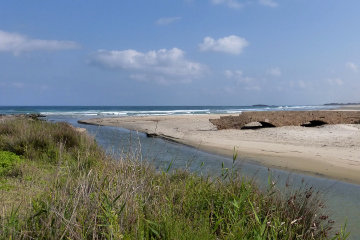
| The 20' thick dam can be clearly seen here, with the sluices that drive the watermills on the right. |
However the most interesting fact to emerge from this account is the description of this dam, twenty-five feet high, six hundred feet long and twenty feet thick. That seems an incredible amount of labour just to drive a few mills. On the other hand, if this dam was intended to create a reservoir to feed the aqueduct, that might indeed justify such a herculean task.
Photographs uploaded to Google Earth do, indeed, show that the dam stored water and fed it into a rock-cut channel which forms the first part of what is later an aqueduct mounted on arches.
If you move your mouse pointer over the picture on Google Earth you can see the elevation of the land beneath the pointer displayed at bottom-right of the screen. These readings are very coarse and are not always accurate. For example, if you run your mouse along the course of the river Zarqa you find that it is 4-5 metres above sea level, but as soon as you reach the sea the elevation rises to 12 metres before dropping to the expected 0 metres. Nevertheless, we can say that the village of Jisr az-Zerqa sits on a north-south ridge that is as much as 25 metres high; Caesarea is 12 metres above sea level, but the area around this dam is only 5 metres high.
Roman engineers were as aware as you and I of the fact that water does not flow uphill. How, therefore, can you get water to travel from a river 5 metres above sea level to a town 12 metres above sea level? The answer is that you build a dam 8 metres high across the gap in the ridge and create an artificial lake or reservoir that is just high enough for the water to flow down a gentle slope of one foot per mile. That may not sound like much, but up at Jerusalem Herod's engineers constructed aqueducts where the gradient was of the order of inches per mile!
I feel really chuffed at thus clearing up the mystery of the Caesarea aqueduct and will certainly take the time to pop along to the Crocodile River next time I visit Israel.
lofty canals By this he means the two channels that run along the top of the aqueduct. The channels are indeed deep - the larger is about two feet deep - but the claim that a man could ride along them on horseback are mere nonsense. However much further north there are a series of arches built over the channel - which here is dug into the ground - and if they were once connected, they do indeed appear to fulfil the reverend's description. Return
© Kendall K. Down 2015