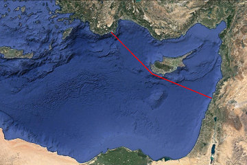
The Perfect Storm
| Caesarea | 32 30 07.66N 34 53 28.569E | The harbour is pretty clear, including some parts which are now underwater. |
| Edremit | 39 34 28.58N 26 56 11.61E | The exact position of the ancient port is not known: probably it has been buried by silt washed down by the two rivers. |
| Myra | 36 15 32.62N 29 59 06.63E | The coordinates are for the theatre at Myra. The ancient shoreline was probably much closer to the theatre than the modern coast and may correspond to the cultivated area that shows up on Google Earth. |
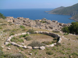
| Cnidus | 36 41 09.73N 27 22 26.66E | The theatre and agora at Cnidus are clear to see as well as the outlines of other buildings. |
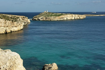
| Cape Sidero | 35 18 57.81N 26 18 43.34E | The cape, known in Bible times as Salmone, is a curious chain of near islands linked only by narrow strips of land. |
| Fair Havens | 34 55 48.69N 24 48 01.33E | There are no ancient remains in the little fishing port of Kali Limenes. |
| Lasea | 34 56 41.33N 24 49 52.84E | There is absolutely nothing to see on this bare hillside. Presumably scattered pottery is what has identified the site. |
| Phenice | 35 11 58.85N 24 04 20.13E | Now known as Sfakia, the ancient port may have been on either side of the headland. |
| St Paul's Bay and Island | 35 57 53.49N 14 24 02.20E | If you get in really close you can see the shadow cast by the statue of St Paul which commemorates his arrival in Malta. |
The Perfect Storm
The story of St Paul's shipwreck is a fascinating account, written by a layman - not a sailor - of a shipwreck in the first century AD and sheds light on sea traffic on the Mediterranean at that time.
According to Acts chapter 27, the voyage started normally enough, with a party of prisoners being dispatched from Caesarea, in Palestine, to Rome escorted by a squad of soldiers from the "Augusta Cohort". We have an army list from the time of Hadrian - who lived some sixty years after Paul's voyage - which names the various army groups that formed the garrison of Syria and Palestine. Among them is I Augusta Thracum eq sagitt. A cohort numbered approximately 1,000 men, but there were probably no more than half a dozen forming the escort for this band of prisoners.
| |
| The harbour at Caesarea as it appears today. The mole is built on Herod's foundations. |
Caesarea, the starting point for the voyage, was built by Herod the Great and the amazing harbour he constructed using great blocks of cement cast underwater, has been described elsewhere on this site. The coast of Palestine is singularly lacking in safe anchorages, so the protected harbour quickly made the city one of the most important in Palestine.
A Roman citizen being transported as a prisoner had certain rights and one of them was that he could be accompanied at state expense by a private physician and a slave to wait upon him. From the fact that the account refers to "us" we understand that Paul was accompanied by the author of the book of Acts, a doctor named Luke.
We are also told that Aristarchus, one of Paul's converts from Thessalonica, was with them, possibly posing as the slave. One has to hope that the devoted Aristarchus was not expected to doss down in the hold with the other slaves! On the other hand, there were civilian travellers on the ship in addition to the prisoners, so possibly Aristarchus was a paying passenger.
Unfortunately there was no ship sailing direct from Caesarea to Rome and when the prisoners and their escort had been assembled, they were forced to board a ship sailing along the coast and hope to find other ships in one of the ports at which they called. The home port of the ship they found was Adramyttium, now known as Edremit, a rather non-descript coastal town through which I have driven several times on my way from Troy to Pergamon, so the natural route would be as Luke describes - "we launched, meaning to sail by the coasts of Asia". In other words, the captain intended to call in at every port along the coast between Caesarea and Adramyttium.
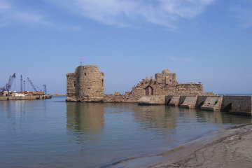
| |
| The main feature of Sidon's harbour today is the Crusader castle. |
The first port of call was Sidon, some eighty miles north of Caesarea. We may speculate on how long the voyage took, because it is unlikely that this cargo ship was a particularly fleet sailer. If it wallowed along at 5 or 6 miles per hour it was probably doing well. Assuming the upper figure, the voyage would take just over thirteen hours, but as this was late autumn, that is longer than the hours of daylight available at the time. As it is unlikely that the ship's captain would try to either leave or enter port in darkness - there were no artificial lights to help him - we may assume that the ship left Caesarea in the afternoon, sailed through the hours of darkness and arrived in Sidon early in the morning of the following day.
We are often told that ancient sailors came ashore at night, but much depended on the weather and the coast. A fine, moon-lit night with the sand of the shore gleaming in the moonlight was one thing; a dark and cloudy sky that blotted out all light so that you couldn't see your hand in front of your face was another! A rocky coast with unexpected headlands and treacherous currents was one thing, the featureless coast of Palestine was quite another.
Luke records that Paul was allowed to stay with Christian friends while the ship was in Sidon, so the ship was probably in port at least overnight while cargo was loaded and unloaded - possibly even while the captain did the rounds of taverns and shopkeepers seeking for a cargo!
It is at this point that we come across one of the frustrations of Luke's account; Luke was a doctor, not a sailor, and although his story does use some nautical jargon which he picked up along the way, he can be terribly obscure at times. He says, "We passed under Cyprus, because the wind was against us. When we had sailed across the open sea off the coast of Cilicia and Pamphylia, we landed at Myra in Lycia."
| |
| Paul's probable route from Sidon to Myra. |
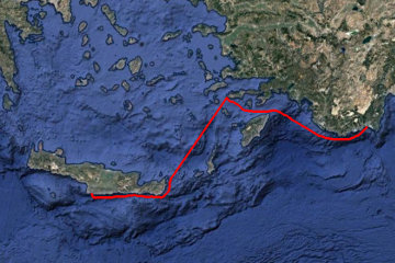
If you draw a straight line on the map between Sidon and Myra, you do indeed pass south of Cyprus (well, in fact, a perfectly straight line passes through the south of Cyprus, but sailing along the coast is not all that much of a deviation from a straight line). However Luke implies that the route was chosen because of a contrary wind. My conclusion is that when the ship left Sidon the wind was coming from the north. The normal next port of call for a coastal trader would be Berytus (Beirut) and no doubt Paul was hoping to call in at his home town of Tarsus a little further on in the voyage, but a north wind would preclude this. Rather than linger in harbour waiting for the wind to change, the captain, all too aware of the approach of winter, decided to head for home by taking the direct route across to southern Turkey.
If the wind was coming from the north or north-east, the voyage to Myra would be just within the capabilities of a first century sailing ship. Modern sailing yachts, with their specially designed sails, can sail within 22 degrees of the wind. The sails form a curved shape and the wind blows across them rather like the air flowing over an aircraft wing. The "lift" thus generated draws the ship forward, so that it is sucked along rather than blown along! However the rig of ancient ships consisted of a single large square sail in the middle of the ship, sometimes balanced by a smaller square sail attached to the bowsprit. The foresail was called the "artemon". A large ship might have two or even three masts, but still only one sail on each mast. A direction of travel of 45 degrees to the wind was about the best such an arrangement could manage.
Today we would understand the phrase "under Cyprus" to mean "to the south of Cyprus, because we are used to north being at the top of our maps. It is not clear that the ancients had a similar picture of the world and it is quite possible that "under Cyprus" meant "in the lee of Cyprus". If the wind was coming from the north, then sailing south of Cyprus would avoid all danger of being blown into the lee shore and would also give the ship some protection from waves whipped up by the wind.
Cilicia and Pamphylia were the provinces along the south coast of Turkey, so the "open sea" would be the sea between the south-western coast of Cyprus and Turkey. The total distance from Caesarea is about 350 miles (avoiding the mountainous interior of Cyprus!) and if we assume 6 miles per hour the voyage would have taken 58 hours or two and a half days. That would involve no more than two twenty-four hour periods out of sight of land, with landfall on Cyprus to confirm (and correct) the accuracy of their navigation midway through the journey. This would be well within the capabilities of any half-way competant sailor who could use the sun, moon and stars as reference points to keep himself on course.
However it is possible that the captain was equipped with an astrolabe, a device invented two centuries earlier by Hipparchus, a Greek astronomer from Nicea. He was the founder of trigonometry (for which generations of schoolboys have, doubtless, been grateful) and his gadget enabled sailors to take accurate readings of the height of heavenly bodies, rather like a modern sextant but without its lenses. It would be too much to expect that a small coastal trader would have something as complicated as the Antikythera mechanism (see articles elsewhere on this site), but it would be equally mistaken to imagine that the captain was an ignorant sailor who relied on guesswork to navigate his way across the Mediterranean.
| |
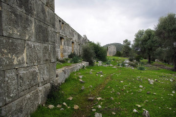
| The remains of the Roman period warehouses in Myra's port. |
Myra was an important port and one of the largest cities in the Lycian League. It is marked by a substantial necropolis of cliff-cut Lycian tombs that look a little like the tombs of Petra. The port for Myra, however, was not south of the city, an area which was already too silted up and shallow in Paul's day, but a deep inlet over to the west, an area now called Andriake. There is a huge warehouse complex built of massive gray stones beside the harbour, but it was constructed under Hadrian, so St Paul would not have seen it - though doubtless there were other, perhaps less substantial, warehouses. Part of Hadrian's warehouse has been restored and now houses the Myra museum.
What Paul would certainly have seen - and smelled - is the mound of murex shells beside the warehouse, mute testimony to the flourishing purple dye business which contributed to Myra's prosperity. The waters off Myra would have been dotted with small craft from which men jumped into the sea and dived for the bottom while holding their breath. Going by the experiences of later sponge fishermen, the casualty rates among these naked divers were horrendous, but the profits to be made from purple made the risks worthwhile.
As far as we know, Paul had not been to Myra before and doubtless he longed to preach the gospel there, but for someone under suspicion of fomenting trouble wherever he went, that would have been a most unwise move. In any case, he may not have had the time because there was an Alexandrian ship in port heading direct for Italy and the centurion in charge was probably desperate not to miss it.
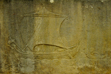
From the description of the efforts made to lighten the ship when it was struck by the storm, we know that it was carrying grain - and these Alexandrian grain ships were the supertankers of the ancient world. The panem et circenses (bread and circuses) policy of the caesars depended on a plentiful supply of cheap grain and Egypt, with its fertile fields and abundant harvests, quickly became the granary of Imperial Rome.
| |
| A Roman grain ship. Notice the small boat being towed behind. Notice also the small foresail. |
For the time, the grain ships were huge, but they were also clumsy; their whole purpose was to transport as much grain as possible as cheaply as possible. The Roman author Lucian describes one of these grain ships, the Isis, which he saw in the port of Piraeus a century after the time of Paul.
What a size that ship was! 180 feet long, the man said, and something over a quarter of that in width; and from deck to keel, the maximum depth, through the hold, 44 feet. And then the height of the mast, with its huge yard; and what a forestay it takes to hold it! And the lofty stern with its gradual curve, and its gilded beak, balanced at the other end by the long rising sweep of the prow, and the figures of her name-goddess, Isis, on either side. As to the other ornamental details, the paintings and the scarlet topsail, I was more struck by the anchors, and the capstans and windlasses, and the stern cabins. The crew was like a small army. They said that she carried as much corn as would feed every soul in Attica for a year, yet it all depends for its safety on one little old goblin of a man, who controls that great rudder with a mere broomstick of a tiller!
Ships and Vows
| |
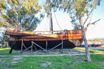
| A modern reproduction of a grain ship - rather smaller than the large vessels of Roman times! |
Based on the measurements given by Lucian, it has been calculated that the Isis displaced approximately 1,200 tons. Even today that is not an insignificant vessel. As Egypt exported some 200,000 tons of grain to Rome each year, that required 200 round trips by ships the size of the Isis and as the number of grain ships was limited, it means that there was pressure on each ship to make as many trips as possible. So great was the demand for these ships that anyone who provided a grain ship was given automatic citizenship and exemption from certain taxes!
Both wind and sea currents favour the voyage from Rome to Alexandria, which Pliny tells us could be completed in as little as a six days. Conversely, however, the direct route back again was almost impossible, which is why we find an Alexandrian grain ship in Myra or Piraeus. The ships had to take a circuitous route north to Asia Minor, then west along the coast of Turkey, across the Aegean and then up towards the heel of Italy before taking advantage of sea and land breezes to make a slow passage north through the Strait of Messina and then along the coast to Ostia. The return journey could take six to eight weeks - or even longer if the winds were unfavourable.
And this was the case with Paul's voyage, for Luke comments that after leaving Myra "we sailed slowly many days". This implies that the wind from the north had died away and the prevailing wind from the west was now blowing. The ship would rely on the coast and sea breezes morning and evening to at least moderate the west wind.
| |
| The probable route of Paul's journey from Myra to Fair Havens, as described by Luke. |
Eventually they reached Cnidus, after which the coast of Turkey runs out and you have to turn north if you want to continue along the coast. However by now they were far enough along that they could turn south and use the prevailing wind to drive them down towards Crete where, once more, they could hope for coastal breezes to help them make progress to the west.
Landfall was at Cape Sidero, which Luke knows as Salmone. He records that they had difficulty in passing it, which is possibly an understatement. There is a mile and a half wide channel between Cape Sidero and a large, rocky island, after which the captain would have had to turn a little to the east in order to round the eastern-most point of Crete, the Palaicastro headland.
Having done that, however, he would have had to turn into the wind again to head south-south-west along the coast of Crete. It is not clear why he chose to sail along the southern coast of Crete instead of the north, but at this time of year, apparently, the wind veers between west and north-west - and a north-west wind would tend to drive the ship ashore. Better by far to be driven offshore, if necessary, than onto the rocky coast of Crete.
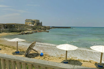
| |
| The anchorage of Kali Limenes, which is open to the east. |
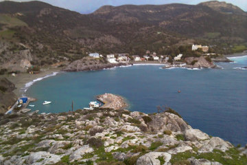
Helped once more by the coast and sea breezes, the next port they reached was Fair Havens. There is some uncertainty over exactly which point on the coast bore this name. There is a modern port called Kali Limenes (Good Harbour), but it is an insignificant little fishing village whose only claim to fame is the small island offshore that is dominated by large oil tanks used for refuelling ships in this part of the Mediterranean. There are no ancient remains in the area.
Six miles further east, however, there is the village of Lentas, site of an Asklepion where wealthy Romans from north Africa came to recover their health. In addition the village was a major port for Gortys, which at one time was the capital of Crete. There are the remains of two large theatres and other buildings on display to the tourist, as well as a large church with a separate, circular baptistry. It is possible that this whole Bay of Loutra was known in Paul's time as "Fair Havens", for Luke mentions the nearby city of Lasea, which is an unexcavated site between Kali Limenes and Lentas.
At this point the ship's captain found himself in a difficult situation. According to Luke, "the fast was now already past". This would be a reference to the Day of Atonement, the only fast in the Jewish calendar. Although Yom Kippur is a moveable date by our calendars, it generally occurs around the middle or end of October. Vegetius, a Roman author of the fourth century AD, tells us in his De re militari 4.39 that it was dangerous to sail on the Mediterranean after the 15th of September and impossible after November 11.
This means that by the time the ship reached Fair Havens they were already well within the dangerous period and must seek a sheltered port in which to pass the winter. As a glance at Google Earth will show, Fair Havens was not a sheltered port! In addition, the facilities it offered on shore were sparse and 276 people require a deal of feeding - and doubtless the sailors at least would require entertaining. Three months in bitter cold is a long time to be bored and Fair Havens had no facilities for so many soldiers and sailors.
Paul, who had some experience of travelling in these waters, advised against any move and the centurion had the authority to order the ship to stay where it was. However the captain was anxious to find a better harbour and in addition there were substantial bonuses available to grain ships which took the risk of arriving late in the season or early the following year. After a couple of days delay, the wind began to blow gently from the south and the captain immediately set sail and headed for Phenice.
Luke comments that this harbour "lies toward the south-west and north-west", but as the ship never reached the place, he can only be going by what the captain told him and there appears to have been some difficulty in communicaiton. Phenice is identified with the little village of Sfakia in southern Crete, which is on the western side of a small peninsula. On the eastern side is the village of Loutra. Both offer reasonable shelter and it may be the fact of the two harbours which led to Luke's somewhat confusing statement.
| |
| The bura batters the coast at Razanac. |
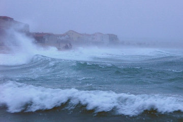
It is only 34 miles from Fair Havens to Phenice, a voyage of six hours or so in good weather. Unfortunately, before they had gone very far the wind suddenly changed and the warm, gentle southern breeze was replaced by the cold, howling gale of a genuine Bura. Luke refers to it as the "Euroclydon", which the Romans called "Euraquilo", a name found in one ancient inscription.
The Bura is strongest in the north Adriatic, where a speed of 188 mph has been recorded. At that speed even road traffic is in danger; ships are in extreme peril! In Trieste when the Bura blows chains are rigged along the streets to which pedestrians can cling, otherwise they are at risk of being blown away. I recorded a short film about the Bura one year when I was giving lectures in Rijeka and just happened to be there when the Bura was blowing. The wind was so strong that during one gust I had to grab at my camera on its professional tripod to stop it blowing over and crashing to the ground!
It must have been terrifying for Paul and the other passengers on the huge, unwieldy ship as the wind caught at it, heeling it over steeply to port. To stop the ship capsizing the captain had to put the steering oars hard over, turning the head away from the wind, at the same time yelling for the crew to lower the sail.
Modern sailing ships can shorten sail by putting a reef in it. Along the width of the sail is a row of short strings sewn to the material, with another row some distance below the first. By tying the top strings to the bottom strings you put a fold in the sail which has the effect of reducing the surface area exposed to the wind. So far as I am aware, neither Roman nor Greek ships could reef their sails. The only alternative, therefore, was to lower the sail, leaving the ship to drift before the wind.
| |
| From Crete to disaster: Paul's probable route from Fair Havens to Malta. |
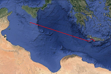
Because they were off the southern coast of Crete and the wind was coming from the north-east, they were in no immediate danger of running aground. Luke records, "As we passed to the lee of a small island called Cauda, we were hardly able to make the lifeboat secure, so the men hoisted it aboard. Then they passed ropes under the ship itself to hold it together. Because they were afraid they would run aground on the sand-bars of Syrtis, they lowered the sea anchor and let the ship be driven along." (Acts 27:16, 17)
Cauda is some 31 miles from Crete if you measure along a line north-east/south-west, which is presumably the direction the wind was blowing them. Depending on their rate of drift, this would have been between four and six hours after the Bura struck and very probably mid-afternoon. Furthermore, by following that line we can see that they had not gone very far on their journey before the storm hit them.
Luke speaks of them passing to the lee of Cauda. The only way in which Cauda could provide them with shelter from the wind would be if they were passing to the west of the island. There are several sheltered bays on the west coast of Cauda, but either the captain was unaware of them or, more likely, the wind direction and the lack of sails made it impossible for him to head east into safety.
What he did do was take advantage of the slight lessening of the wind to pull the ship's boat on board. Ancient depictions of sailing ships sometimes show a small boat being towed along behind the large ship. As the size of a grain ship meant that it had a deep draught, only the largest ports could accommodate it. In smaller ports the sailors would use the ship's boat to ferry themselves ashore and back out to the ship again. To describe it as a "lifeboat" - as the New International Version does - is a complete misnomer. It had none of the aids to bouyancy and life which a modern lifeboat takes for granted and was nothing more than a small rowing or sailing dinghy.
The NIV is equally creative - and equally wrong - when it speaks of "lowering the sea anchor". Ships caught in a storm may drop a sort of parachute into the water, often formed by lashing three or four oars together to form a frame and tying a sail to the oars. By dragging in the water as the ship is blown along a sea anchor does two things: if you attach it to the front of the ship you ensure that the ship is blown backwards, which means that the prow is constantly facing into the wind and therefore facing the oncoming waves. This is what a ship is meant to do and so it is in less danger than if the waves were coming from astern or to the side.
The other thing a sea anchor does is slow the speed of the ship's drift. However modern sailors have discovered that by fastening the sea anchor to some point on the side of the ship you can cause it to adopt a certain angle to the wind and therefore give it a degree of sideways drift - but the predominate direction is still away from the wind. The track followed by Paul's ship is almost directly west - no drifting to the south at all - a fact which in itself argues against a sea anchor.
Despite a deal of research, I have only found one reference to a sea anchor before the first century AD and it is so obscure that we cannot be certain that it is indeed talking about a sea anchor. Luke actually says that the sailors "lowered", without specifying what was lowered, but it seems obvious to me that they not only furled the sail but lowered it as well - and possibly lowered the spar that held the sail, in order to lessen the area on which the wind could catch.
The third thing the sailors did was to tie ropes around the ship. This action stemmed from a peculiarity of ancient ship construction. In a modern vessel the shipwrights lay down the keel, then erect ribs from the keel and attach the hull - planks of wood or sheets of steel - to the ribs. Ancient boat builders laid down the keel and then built the hull up from there. The planks of wood were fitted together with mortice and tenon joints - matching slots cut in the edges of the planks into which pegs of wood (the tenons) were fitted. When the two planks were pressed together the tenons held them in place and could be strengthened by pegs driven through both plank and tenon.
Once the ship was complete ribs would be fitted, but their purpose was to keep the sides of the ship apart against the pressure of the ropes which ran from keel up to the deck and were tightened with windlasses. In view of the storm, the sailors tightened these ropes to keep the ship from working itself apart!
In addition many ships had a pair of very thick ropes known as the hypozomata, which ran from stem to stern at just below deck height. As a wave passes under a ship you have the situation where it is supported at front and back by waves but the middle is relatively unsupported. This is known as "hogging". As the wave moves on, however, you may reach the point where the middle of the ship is supported and it is the ends which are unsupported and this is known as "sagging". The constant alternating between hogging and sagging imposes tremendous strains on the ship's structure and the hypozomata were intended to prevent sagging. These ropes were so important that during the time of Athenian naval supremacy, it was a capital offence to export them out of Athens.
There is a bit of sailors' folklore which claims that the Euroclydon will usually blow itself out in three days. However if it lasts longer than three days then it is going to blow for fourteen days. The captain and crew of St Paul's ship must have hoped that the storm would be over in three days and no doubt their hearts sank when the fourth day dawned with the wind as strong as ever. It was at that point that the captain decided to throw some of the ship's tackle over the side.
They had already lightened the ship by throwing the cargo overboard - though it is unlikely that they disposed of the entire cargo. In the first place it would have taken several days to carry hundreds of tons of grain up from the hold. In the second place, too light a ship is even more dangerous than too heavy a ship. When sailing empty, sailing ships loaded themselves with ballast - usually big lumps of rock - to provide stability and prevent themselves being blown over by the wind.
Getting rid of the ship's tackle may seem extreme, but any well-found ship carried spare spars, planks and ropes, possibly even a spare steering oar or two. With waves washing over the deck these things were a danger to the ship, for if they came loose they might have caused structural damage to the masts, rigging or even the hull.
Now we need to turn back to the question of a sea anchor. Luke states that the crew "were afraid they would run aground on the sand-bars of Syrtis". Syrtis is that huge bay in the north coast of Africa between Egypt and Algeria which is still known as the Gulf of Sirte. It was believed that the coast was lined with quicksand and any ship which ran aground would be quickly swallowed up, along with all its crew.
(There is an old Roman map dating to the fourth century AD but based on a map prepared under Augustus, known as the Tabula Peutingeriana. If you click on this link you can find a reproduction of the Tabula. Scroll slightly more than half-way to the right and there is a small bay with a curious spiral, a bit like a snail's shell, in the southern coast. That is how the Romans understood the Gulf of Sirte. Crete is the large island labelled "Insula Cretica" a bit to the right of Sirte.)
In fact the reality was somewhat different. I read of a French destroyer during the Second World War which ran aground somewhere on this coast during a violent storm. By the time the wind died down, so much sand had been washed and blown around the ship that it was actually a dozen yards inland! As I recall, it took some serious digging to free the ship so that it could be towed away for repairs.
It is likely that sailors, passing along this coast, would see ships surrounded by sand and conclude that they had been swallowed by quicksand, when in fact they had merely been overwhelmed by wind-blown sand.
However even if you survived the sands, the locals were known as Garamantes and the ancient world did not have a high opinion of them. I don't think anyone actually claims that the Garamantes ate babies, but that was about all that you could say for them! At the very least these wild tribesmen would enslave shipwrecked sailors, but theft and murder were more likely.
If you project a line from the west side of Cauda to the south-west, it is only some 485 miles to the coast of Africa inside the gulf. If you take a point on the bulge that marks the eastern limit of the gulf, the distance is only 185 miles. At 6 miles per hour, the ship could cover that distance in 30 hours, well within the three days of the shortest Euroclydon storm.
If the captain had lain to, drifting behind a sea anchor, he would without doubt have ended up at one of these two points. I have read learned commentators speculating that by turning the bows to the wind and using a sea-anchor the captain could cause his ship to drift at right-angles to the direction of the wind. That is pure poppycock. Even if the ship does move at right angles to the wind, it will primarily move in the direction the wind is blowing.
On the other hand, if you draw a line between that same point on Cauda and the place where they actually ended up - St Paul's Bay on Malta - you will find that they travelled some 544 miles in a west-north-west direction. That is clear evidence that the captain did not tamely throw out a sea anchor and commit himself to the vagaries of wind and wave. Although the mainsail was lowered, as Luke says, he must have kept the foresail (or a smaller version of the foresail, a sort of storm sail) up and fought the storm every inch of the way, using every ounce of seamanship he possessed.
It was only the most rotten luck that the voyage ended disastrously. A fraction of a degree to either side during their voyage and they would have safely passed Malta with another 220 miles to go before they reached the western side of the gulf - and surely, by then, the storm would have ended. If it took them fourteen days to travel the 544 miles to Malta, it would have taken another five days to reach the coast of Africa.
Indeed, as the final day of the voyage dawned, the captain must have been congratulating himself. The storm was surely in its final stages, the ship was intact, everyone was still alive. Some cargo and tackle had been lost, it was true, but nevertheless it had been a creditable performance by captain and crew. As the sun set they may even have gone to bed cheerful, expecting that by morning the storm would be over.
Alas, in the early hours of the morning the keen ears of the men on watch detected the sound of breakers in the distance. They took soundings, by throwing a lead-weighted rope over the side and measuring the length of rope that paid out before the weight hit bottom. According to St Luke, the result was a depth of twenty "orguia", a word that refers to the distance between a man's outstretched arms. The NIV reckons on this being 4'6" and translates the depth as "30 metres", but it is not clear that the ancients had a standard orguia!
In any case, the significant thing was not the absolute depth but the fact that a short time later they heaved the line again and found that the depth had decreased to fifteen orguia. This was a sure sign that they were approaching land and in the darkness they could not tell whether the shore was a gently sloping sandy beach or jagged cliffs. Very prudently they dropped four anchors from the stern.
Archaeologists have found two different types of anchor in use in the Roman world. The first - and oldest - is nothing more than a big lump of rock with a hole pierced in one end. You tied a rope through the hole and threw the rock overboard, hoping that the weight of the rock would be sufficient to hold the ship in place. The use of four anchors may imply that this is the sort of anchor carried by this particular ship.
The other type was more like the anchor with which we are familiar. It was of wood, with flukes at a sharp angle to the shaft and a heavy metal - usually lead - stock at the top of the shaft, whose purpose was to press the anchor down onto the seabed and encourage the flukes to dig into the bottom. We do not know which type of anchors this ship carried; it may even have had both, as the block of stone would be more effective on a rocky bottom than the wooden anchor, which would not dig into the rock.
The bottom in St Paul's Bay is a fine clay and British Admiralty sailing directions from the Nineteenth Century assure captains that anchors, once properly caught on the bottom, will never pull lose from the clay. In fact, when the captain decided to run the ship ashore it proved impossible to pull the anchors up and he was obliged to cut the cables and abandon them.
Levantine sailors have a fine tradition of abandoning their passengers on a sinking ship - does anyone remember "Captain Coward" of the Costa Concordia? - and these sailors were no exception. As soon as the sky began to lighten they lowered the ship's boat over the side, intending to leave the unwieldy grain ship to its fate and escape in the row boat. When challenged they explained that they needed the boat to lay out anchors from the front of the ship.
In one of his letters St Paul remarks that he had been shipwrecked three times and on one occasion had been adrift in the sea for twenty-four hours before being rescued. (2 Corinthians 11:25) He realised that putting out anchors from the bows did not make nautical sense - the ship needed to be free to ride the waves rather than fastened to the bottom at front and rear - and divined the real purpose of the boat. He warned the centurion in charge that if the sailors got away the passengers were doomed. The centurion took decisive action: he drew his sword and slashed the rope holding the boat and the sailors were forced to watch as the wind caught it and drove it away into the darkness.
Dawn revealed a low-lying coast which the captain was unable to identify. However straight ahead was a "kolpos" with what looked like a beach on which they could run the ship ashore. When a Greek donned his chiton the garment was too long; he tied a girdle around his waist and then pulled the cloth up, creating a fold that hung down over the girdle. This was called "kolpos" and was useful in the same way that pockets are useful - you could carry your purse or your Swiss Army Knife in your kolpos. The word would seem to indicate that in front of them was a deep inlet rather than a wide bay, and we may presume that the beach was at the head of this inlet.
| |
| St Paul's Bay on a calm day. The monument in the centre of the picture is supposed to mark the site where Paul came ashore. |
There are two deep bays in the north of Malta (with a smaller one to the south), but it is the middle bay that has been selected by tradition as the site of Paul's shipwreck. In fact, a small island at the north of the entrance to the bay is claimed to be the "very spot" and a prominent statue of St Paul commemorates the apostle's unwilling arrival on Malta.
While we cannot know the exact angle at which the ship approached Malta, if we continue the line from the south-western corner of Cauda to the entrance to St Paul's Bay and if we assume that they narrowly missed being driven ashore on the rocks on the south side of the entrance - Koura Point - that line points directly to St Paul's Island, which is either a remarkable coincidence or points to the tradition being a genuine folk memory.
However there is a difficulty if we assume that the wind was still coming from the north-east. In that case all the captain had to do was turn the steering oars slightly and allow the wind to drive them into the bay. There are three possibilities: the first is that the steering gear had been damaged by the storm, but this seems to be contradicted by the statement that the sailors "loosed the rudder bands" (KJV) or "untied the ropes that held the rudders" (NIV). They would not have bothered to do that if the steering oars were damaged or broken.
The second - and more likely - possibility is that during the two weeks of storm the wind had changed direction, veering round from north-east to east. It would be unusual (though not impossible) for a wind to blow from the same direction for such a long period of time and over such a wide expanse of sea. Nearby land masses (or their absence, as in between Greece and Italy) would surely have had their own effect on the wind direction.
However it is the third possibility that is the most likely, and that is that when dawn came the ship was dangerously close to St Paul's Island. No matter what effort they put into manipulating the steering oars or setting the foresail, before the ship gained enough speed through the water to respond to the tiller it was aground and the waves were pounding at the stern and smashing it to pieces.
The NIV claims that the ship ran aground on a sand bar, but a quick view of Google Earth does not show any sand bars in the area and while it is possible that the ancient sea bed was significantly different from the modern one, it is, in my opinion, improbable. Sand banks do not just form on a whim: there is usually some feature of the topography or the currents which traps the sand and heaps it up into a bank. Although erosion may have altered the coastline a little, the winds and currents will not have changed.
The KJV speaks of the ship "falling into a place where two seas met", a phrase that has been much commented upon, but may simply refer to the fact that the waves divided as they struck St Paul's Island, washed around either side of it and then came together again in the narrow channel between the island and the mainland of Malta. If this is the correct interpretation, then we can fix the site of St Paul's shipwreck as somewhere near the narrow strait between St Paul's Island and the mainland of Malta.
In fact, the ship may actually have passed between the island and the mainland before running aground. The cliffs around St Paul's Island and on the northern shore of the bay would surely have stopped the survivors coming ashore. However once through the narrow channel there is a gentle beach to port. If that is considered too improbable, then there is a little bay with a fine beach a short distance to the west of St Paul's Island. Either is preferable to imagining the starving crew and passengers scrambling up the cliffs while being pounded by the waves.
© Kendall K. Down 2017