The Greenland Mystery
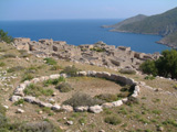
| Hvalsey | 60 49 42.62N 45 46 56.80W | The rectangle of the church walls is clear to be seen, as are the ruins of farm buildings beside it. |
In the first lesson of the free introduction to Middle Eastern archaeology course available on this website, I discuss some of the techniques of archaeology, among which is the reading of crop markings. Not to be confused with "crop circles" - those geometric patterns made in wheat fields by little green men from Mars/drunken college students (take your pick of explanations) - crop markings are a direct result of human activity over the years.
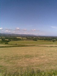
Imagine, if you will, a hill-fort on the Sussex Downs, which has entirely disappeared due to erosion or ploughing. Most of the area is a thin layer of soil over the chalk of the downs, but where our ancient forebears excavated a defensive ditch - which has since been completely filled by wind- or water-borne mud - the soil is three or four feet deep. If you know anything at all about horticulture and farming, you will not be surprised to learn that the most crops grow more strongly where the soil is deepest. The result is that the line of the ditch is marked by a circle of darker green which is certainly visible from the air and in many cases can be seen from the ground.
Even where you don't have fields rich with crops, a knowledge of local flora can still be useful. I forget who the archaeologist was who walked over a desert plain in Syria, pointing out the location of tombs to his companion, who could see nothing whatsoever and rather thought that the expert was joking. Although the vegetation in this location was sparse, he was in fact noticing the places where a particular plant grew which, he knew, developed long roots. He reasoned - correctly, as it turned out - that such roots would not grow through rock, so if one of those plants grew in a particular spot, it must be because there was a tomb shaft there.
There was a curious instance of crop markings in Kenya, where a tea plantation was planted over the remains of ancient huts that had been whitewashed with lime. Apparently tea bushes are sensitive to lime and those planted over the hut sites died. On the ground it was difficult to see what was going on, but from the air the outline of the ancient settlement was clear.
Rob Commisso and Erle Nelson from Simon Fraser University in British Columbia have taken this a step further. Although they could see nothing different on the ground, they collected plants from sites in south-west Greenland and carefully recorded the location from which they had taken each one. Then, during the long winter nights, they analysed the plants to determine the amount of nitrogen in the leaves. To their delight, they found that some of the plants had an unusually high concentration of nitrogen-15.
The two men knew that human activity results in a higher concentration of nitrogen-15, derived from the rubbish people throw out as well as the animal waste piled on the farmyard midden. They suspected, therefore, that their nitrogen-15-rich plants were an indication that buried farmyards lay below and subsequent excavation confirmed their hunch.
|
| The ruins of Hvalsey church stand by the water's edge. |

Greenland was settled by the Vikings from 986 onwards and for a time their two settlements at the south-western tip of the island flourished, but around 1300 the weather began to deteriorate as the Little Ice Age set in. As summers shortened and ice grew thicker in the fjords life became increasingly hard for the Norsemen, but at the same time the native Inuit found conditions to their liking and conflict flared between the two peoples. The last written record from Greenland refers to a marriage in 1408 celebrated in the church at Hvalsey which stood on a farmstead founded by Erik the Red's uncle! The bride was a local girl, the husband was captain of a ship which had been blown off course and arrived in Greenland by chance two years before.
Two years later the happy couple boarded their ship and sailed away, never to return and over the next century the rest of the Viking settlements in Greenland were abandoned. The middens and farmsteads located by Commisso and Nelson tell the harsh story: first cattle disappear and only sheep and goats remain, then caribou remains take the place of both - probably wild caribou hunted for meat - and finally only seal bones are found.
Some have suggested that in fact the cattle were killed, not by increasing cold but by encroaching Inuit, moving down from the north. As hunters, the Inuit would have viewed the Viking cattle as conveniently located game and not understood the concept that such animals belonged to others. Naturally this led to conflict between the two peoples and it is interesting that while many Viking objects have been found in Inuit contexts, very few Inuit objects are found in Viking settlements. This has been interpreted in two ways: either the Inuit raided the Vikings (we know that they did so) and stole anything they could, or the Vikings traded their possessions for food - perhaps the seal bones found on the middens.
In 1345 the pope excused the Greenlanders from paying tithes because of their poverty and things got worse as time went on. The latest radio-carbon date found in these Viking houses is 1430 and it would seem that there were no permanent settlements after that date. Of course, as more nitrogen-rich plants are found and the remains they signal are uncovered, it may be that the history of the Vikings in Greenland will be extended - and all because of invisible crop-markings.
nitrogen-15 Growing plants absorb nitrogen from the soil, primarily nitrogen-14 but a trace of nitrogen-15 is also present. Return
© Kendall K. Down 2009